

Ocean Passages for the World and cruising route guides
1The lesson in plain words
Ocean route guides turn the climate charts into recommended routes for each month. Read the official one for ships and a yachting guide for small craft.
Ocean Passages for the World
NP136 Ocean Passages for the World, from the UK Hydrographic Office, is the standard guide for planning deep-sea voyages. It now comes in two volumes: the Atlantic, and the Indian and Pacific Oceans. For each ocean, it describes climate, winds, currents, swell, seasons and ice. It also gives recommended routes, distances and route diagrams, plus small charts of climate, wave heights and load line zones. Weekly Notices to Mariners keep it up to date.
Guides for yachts
NP136 is written for ships, which can motor through calms and head seas. Yachts need routes that follow the wind. World Cruising Routes by Jimmy Cornell gives hundreds of yacht routes with the best times, waypoints and dangers; regional pilot books add harbours and local detail. Check the edition date: seasons and services change.
Shortest is not quickest
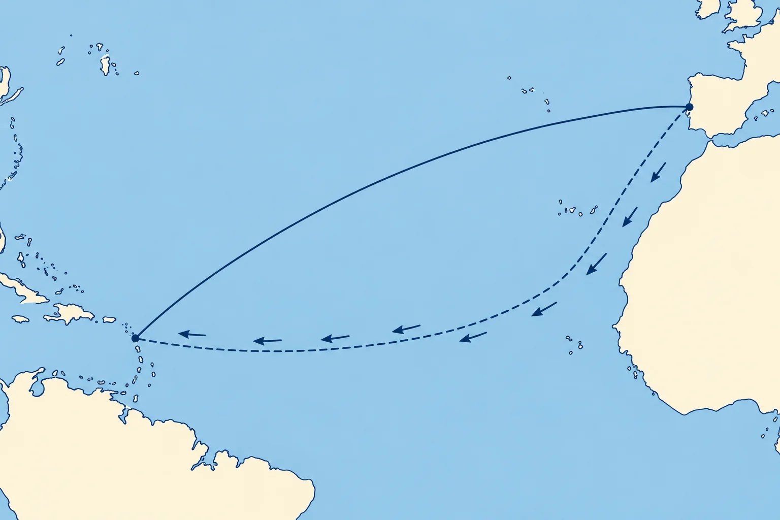
The shortest route across an ocean is the great circle; the Great-circle sailing unit shows how to work it. A sailing route often goes far from it, to find fair winds and currents and avoid storms, calms and ice. The trade-wind route from the Canaries to the Caribbean runs south-west first, then west: longer than the great circle, but usually faster and more comfortable.
Building the route
Start from the guide's recommended route for your month. Check it on the routeing or pilot chart for that month. Mark the hazards: storm tracks and seasons, ice limits, calm belts, strong currents. Then add your own waypoints, alternative ports and decision points where you will check forecasts and choose between options.
Official sources first
Use NP136, the routeing charts and official sailing directions as your reference, and private guides for yacht detail. Where they disagree, the more cautious one wins until you have checked why. The Nautical publications unit covers sailing directions and keeping them corrected.
2Key data
- NP136
- Ocean Passages for the World (UKHO), two volumes
- NP136 contents
- Climate, currents, ice, routes, distances, load line zones
- Updates
- Weekly ADMIRALTY Notices to Mariners
- Yacht route guide
- World Cruising Routes (Cornell): yacht routes and best months
3Key points
- 1
NP136 Ocean Passages for the World gives ocean climate and recommended routes and distances.
- 2
Ship routes assume power; yacht routes follow the wind, so add a yachting guide.
- 3
The great circle is shortest, but a sailing route may be faster.
- 4
Build the route from the guide, check it on the monthly chart, then add waypoints and decision points.
4Frequent mistakes
Wrong: The great-circle route is always the best ocean route for a yacht.
Right: Wind, current, storms and ice decide. A longer route in fair winds is often faster and safer.
Wrong: Any edition of a route guide will do: oceans don't change.
Right: Seasons, services, regulations and recommended routes are revised. Check the edition and the corrections.
5Practice case & exam keys
You want to sail from Gibraltar to Antigua in December. The great-circle distance is about 3,200 miles; the route via the Canaries and the trade winds is about 3,500 miles as sailed. Which do you choose?
Show the answer
Usually the trade-wind route. The great circle crosses the Azores High and the westerlies, with headwinds, calms and winter gales. The route south-west to the Canaries and then west in the north-east trades is about 300 miles longer, but normally gives fair winds and current, so it is faster and more comfortable. Confirm with NP136, a yacht guide and the December pilot chart.
Exam keys
- NP136 Ocean Passages for the World: ocean climate, recommended routes and distances; two volumes.
- Yacht routes follow the wind: use a yachting route guide as well as the ship guide.
- The great circle is the shortest route; the climatic route is often faster under sail.
- Check editions and corrections; official sources are the reference.
Finish this unit
When you've read it, match the terms, then answer three questions. Get them all right to finish the unit; opening the page alone doesn't count.
My notes for this unit
No notes