
IALA buoyage · Level R3 · 4 parts · about 13 min
Lighthouses, sector lights, leading lights and light ranges
4 short parts: Major lights · Sector lights · Leading lights · Light ranges. Each part explains the idea, then gives the points to remember, the common mistakes, a worked case and a practice question; the Academy unit adds all 26 check questions.
1 · Major lights
Lighthouses and the List of Lights
A lighthouse is a landmark by day and a long-range light by night. The chart shows the basics; the List of Lights gives the full details.

What a lighthouse is
IALA defines a lighthouse as a tower or substantial structure at a fixed place, carrying a light. By day its shape and colours make it a daymark, a landmark you can recognise. By night it shows a long or medium-range light.
Identifying a light
You identify a major light by its character: rhythm, colour and period, as in the light characteristics unit. Nearby lights may share a character, so check the expected bearing and position too. Many powerful lights show a loom, a glow in the sky, before the light itself rises above your horizon.
The List of Lights
The chart gives a short legend; the List of Lights gives more: position, character with each phase in seconds, elevation, range, structure, sectors and remarks. The UK publishes the ADMIRALTY List of Lights and Fog Signals in 15 volumes, A to Q (NP74 to NP88), on paper and as the ADMIRALTY Digital List of Lights (ADLL). The US NGA publishes Pubs 110 to 116, free online; US waters are in the US Coast Guard Light List.
International numbers
Where provided, an international number, such as A1234, identifies the same light across lists and Notices to Mariners, which report changed or failed lights. It may not appear on your chart: match the charted position, name and character to the list entry. USCG lists also use local numbers. Read each volume’s introduction for its abbreviations and conventions.
Cautions
A light can fail or be changed before a notice reaches you. Aero lights for aircraft are often brighter than marine lights, but they are not maintained for ships. Wind farms carry marine navigation lights as well as aviation warning lights; rotating blades can make some lights seem to flicker. Bright lights ashore can hide a weak light. Identify every light by its full character and its bearing before you use it.
Key figures
- ADMIRALTY List of Lights
- 15 volumes, A to Q (NP74–NP88); paper and digital
- NGA List of Lights
- Pubs 110–116; coasts outside US waters; free online
- US waters
- US Coast Guard Light List
- ADLL
- ADMIRALTY Digital List of Lights
- Loom
- Glow of a light still below the horizon
Remember
- A lighthouse is a daymark by day and a long-range light by night.
- Identify a light by its full character, timed over several periods.
- The List of Lights holds the full details: phases, sectors, structure.
- Distinguish wind-farm marine lights from aviation lights; confirm each light against the chart and list.
Common mistakes
Wrong: The chart legend gives everything the List of Lights does.
Right: The list adds phases, sectors, structure and remarks. Use both.
Wrong: A bright light on the coast is the lighthouse you expect.
Right: Time its character and check its bearing. Aero lights and shore lights can be brighter.
Worked case
Two white lights are near the expected lighthouse bearing. The brighter one flashes every 5 seconds; the weaker one matches the charted two flashes every 10 seconds. Which can you use, and what must you check first?
Show the answer
The weaker light is the candidate, regardless of brightness. Time several complete periods, compare its full character with the current List of Lights, and check its bearing against the chart. Use it only when both match.
Practice question
What does a lighthouse provide by day?
- A daymark, a recognisable landmark
- A coloured sector to steer by
- A sound signal for poor visibility
- A radar signal in every direction
Show the answer
Answer: A. By day the structure itself, with its shape and colours, is a daymark.
2 · Sector lights
Sector lights: colour by direction
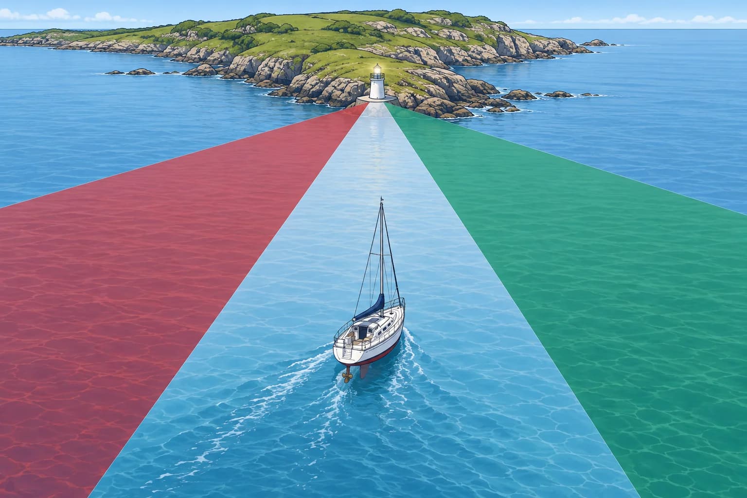
A sector light shows a different colour or rhythm depending on your bearing from it. Its limits are true bearings from seaward, read clockwise.
What a sector is
A sector light shows different colours, or different rhythms, over set arcs of the horizon. The colour you see tells you which arc you are in. Sector lights mark safe approaches, turning points, channel junctions and dangers. An arc where the light cannot be seen is obscured; the arc where it shows at all is its arc of visibility.
How bearings are given
Sector limits in the List of Lights and on the chart are true bearings, from 000° to 359°, given clockwise and from seaward: they are bearings of the light as you would take them from your boat. So a white sector 358°–002° means you see white while the light bears between 358° and 002° from you.
Which colour where
Where a sector light marks the edges of a channel, IALA says its colours follow the region’s lateral rule. In Region A you then usually see red on the port-hand side and green on the starboard-hand side, with white in the middle. Not every light follows this, and many sectors mark dangers, so read each light on the chart and in the list.
Worked example
A light shows green 352°–358°, white 358°–002° and red 002°–008°. The chart marks white as your approach sector. Heading about north towards it, you see green, and a hand-bearing compass gives the light at 355°T. That is below the white limit of 358°, so you are east of the white sector, on its starboard-hand side. Alter to port until the light turns white again.
Edges are not sharp
At each colour boundary there is a narrow arc of uncertainty, where the light may look white, mixed or dark. In cold or wet weather, frost and moisture on the lantern widen it, and coloured sectors may look white. Never steer along a sector edge, and check your position with a compass bearing of the light.
Key figures
- Sector limits
- True bearings, clockwise, as seen from seaward
- White 358°–002°
- You see white while the light bears 358° to 002°
- Arc of uncertainty
- Narrow zone at each edge; wider in frost or rain
- Obscured sector
- Arc where the light cannot be seen
Using a sector light to enter
- Find the light on the chart and in the List of Lights, and note each sector’s colour and limits. — You need to know which colour lies on which side before you see it.
- Identify the light by its full character before using its colour. — Another light nearby may show similar colours.
- Follow the sector shown for your planned safe approach, within its charted limits. — White alone does not guarantee safe water for your boat.
- If the colour changes unexpectedly, check your bearing and chart before correcting along the safe route. — A colour change may indicate a planned turn or danger. Confirm your sector before altering.
- Check with a hand-bearing compass and the echo sounder. — Sector edges are not sharp, and a light can be wrongly set.
Remember
- Sector limits are true bearings from seaward, read clockwise.
- The colour you see tells you which arc you are in.
- Edges are blurred: confirm with a compass bearing, never steer on the edge.
- Which colour lies where depends on the light: read the chart.
Common mistakes
Wrong: Sector bearings are given from the light out to sea.
Right: They are bearings of the light from seaward, as you would take them from your boat.
Wrong: Green always means safe water in a sector light.
Right: Read the chart to see which sector, if any, marks your approach.
Wrong: The colour changes exactly on the charted bearing.
Right: There is an arc of uncertainty at each edge, wider in poor weather.
Worked case
A light’s sectors are green 090°–095°, white 095°–099° and red 099°–104°, from seaward. The chart marks white as the approach sector. Heading east towards it, you see green, and your hand-bearing compass gives the light at 093°T. Where are you, and what do you do?
Show the answer
The bearing, 093°, is below the white limit of 095°, so you are south of the white sector, on its starboard-hand side as you head east. Alter to port, northwards, until the light turns white and bears between 095° and 099°, then steer to keep it white. Confirm with the depth and further bearings.
Practice question
How are sector limits given in the List of Lights?
- Magnetic bearings from the light
- True bearings from seaward
- Relative bearings from the bow
- True bearings from the light
Show the answer
Answer: B. Sector limits are true bearings of the light as seen by an observer from seaward.
3 · Leading lights
Leading lights and directional lights
Leading lights form a line to follow: keep them in line and you are on the track. A directional light does the same job with one light and a narrow beam.

Leading lights
Leading lights are two or more lights placed so that, seen one above the other, they mark a leading line to follow, often through a narrow entrance. The rear light stands higher and behind the front one. The chart shows the line and its true bearing from seaward, for example Ldg Lts 270°. Holding them in line keeps you on the track.
Off the line
When approaching with the lights ahead, steer towards the front light, the lower and nearer one, if they separate. If the front light appears to the right of the rear one, you are to the left of the line: steer to starboard. Leading lights are often synchronised, flashing together, which makes them easier to pick out against shore lights. Day transits are in the Pilotage unit.
Directional lights
A directional light (Dir) shows a very narrow beam, often white, flanked by sectors of other colours or of much weaker light. It marks a line on its own, without a second light. The chart draws the line with its bearing, for example a Dir WRG light with the bearing of its white beam alongside.
Lights in line
Lts in line tells you that lights align; it does not by itself establish a safe track. They may mark an area boundary, cable alignment or anchoring limit. Check the chart and List of Lights before treating the alignment as a route.
Use with care
A leading line is safe only along its charted length; leave it at the turning point in your plan, even if the lights stay in view. In a cross-current, point the bow towards the side the current comes from by enough to keep the lights in line.
Key figures
- Leading lights
- Rear light higher; keep both in line
- Off the line
- When approaching, steer towards the front light
- Dir
- Single light with a very narrow sector marking a line
- Lts in line
- An alignment; check whether it marks a track or a limit
- Bearing on the chart
- True, as seen from seaward
Remember
- Keep leading lights in line to stay on the leading line.
- When approaching with the lights ahead, steer towards the front (lower) light to regain the line.
- A directional light marks a line with one narrow beam.
- “Lts in line” describes an alignment; check whether it marks a track or a limit.
Common mistakes
Wrong: When approaching, steer towards the rear light when the lights separate.
Right: When approaching with the lights ahead, steer towards the front, nearer light until they line up again.
Wrong: Any two lights in line mark a safe track.
Right: Check the charted purpose. “Lts in line” may show limits or cables rather than a safe track.
Worked case
You are entering on leading lights bearing 270°T. The front light moves left of the rear light just as you reach the planned turning point. Do you regain the line or turn?
Show the answer
Turn as planned. The front light to the left shows that you are north of the leading line, but that line is only valid along its charted length. Do not continue towards the lights to regain alignment beyond the planned turn. Before the turning point, you would correct to port.
Practice question
Which leading light is usually higher?
- The front light
- The rear light
- Both are equal
- The brighter one
Show the answer
Answer: B. The rear light stands higher and behind the front one, so both can be seen in line.
4 · Light ranges
Luminous, nominal and geographical range
How far away will you see a light? Three ranges answer different questions. The chart gives the nominal range; the real answer is the smaller of the other two.

Luminous range
Luminous range is the greatest distance at which a light can be seen at a given time, set by its intensity and the meteorological visibility, how far you can see in the present weather. It ignores the light’s height, your height of eye and the curve of the Earth. In haze it shrinks; in very clear air it grows.
Nominal range
Nominal range is the luminous range when the meteorological visibility is exactly 10 nautical miles. It is a standard measure of the light’s strength, so lights can be compared. Modern charts and Lists of Lights give the nominal range, following the IHO standard. A few national lists still use another range; the list’s introduction says which.
Geographical range
Geographical range is the greatest distance allowed by the Earth’s curve. It depends on the light’s elevation, its height above the stated sea-level reference, and your height of eye, the height of your eyes above the water. Standard tables allow for atmospheric refraction, the bending of light through the air. Raising either height increases geographical range.
Which one counts
You can see a light only up to the smaller of its luminous and geographical ranges. The List of Lights has a luminous range diagram to convert nominal range for the present visibility, and a geographical range table. A strong light first appears, or dips out of sight, at its geographical range; working a distance off from that is in the Advanced fixes unit.
Worked example
A light has nominal range 9 M and elevation 70 m. Your height of eye is 8 m and the visibility about 20 NM. The table gives a geographical range of 22.7 NM; the diagram gives a luminous range of about 13 NM. The smaller is 13 NM, so expect to see it at about 13 NM. It will not dip on the horizon: it is too weak to reach that far.
Key figures
- Luminous range
- Intensity and present visibility; ignores heights
- Nominal range
- Luminous range at 10 NM visibility; on the chart
- Geographical range
- Light elevation, height of eye and the Earth’s curve
- Visible range
- The smaller of luminous and geographical range
- Light elevation
- Above mean high water springs (MHWS), unless notes say otherwise
Remember
- Charts give the nominal range: the light’s strength at 10 NM visibility.
- Luminous range allows for the visibility; geographical range for the heights.
- You see a light only up to the smaller of luminous and geographical range.
- A weak light may never reach its geographical range, so it will not dip.
Common mistakes
Wrong: The charted range is the distance at which the light rises over the horizon.
Right: That is the geographical range. The chart gives the nominal range, a measure of strength.
Wrong: A light is always visible out to its nominal range.
Right: Nominal range assumes 10 NM visibility. Clearer air can increase luminous range; haze reduces it. The horizon may limit either.
Wrong: Raising your height of eye always increases the distance at which you can see a light.
Right: It increases geographical range, but leaves luminous range unchanged. It helps only while geographical range is the smaller limit.
Worked case
A light has nominal range 19 NM. Earlier visibility was 20 NM, giving luminous range about 32 NM; geographical range is 20.4 NM. At 18 NM you still cannot see it, and visibility has fallen to 5 NM. Does that prove the light has failed?
Show the answer
No. The earlier luminous range no longer applies. Use the luminous range diagram with nominal range 19 NM and the new visibility of 5 NM, then compare that result with 20.4 NM. Reduced visibility may hide a working light. Do not treat its absence alone as proof of failure.
Practice question
Which range is shown on modern charts?
- Geographical range
- Luminous range
- Nominal range
- Radar echo range
Show the answer
Answer: C. Charts and Lists of Lights give the nominal range, the luminous range in 10 NM visibility.