

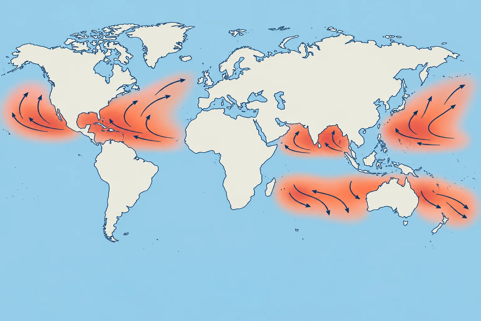
Storm basins, seasons and typical tracks
1The lesson in plain words
Each ocean basin has its own storm season. Know the dates for your route, and remember that storms can also form outside them.
Where and when
Tropical cyclones form in several basins, mostly in the late summer and early autumn of their hemisphere, when the sea is warmest. Season dates and usual activity windows are not guarantees: in some years Atlantic storms form in May or December. The South Atlantic and the south-east Pacific are almost free of them, because of cool water and strong shear. Only one hurricane is on record in the South Atlantic, off Brazil in 2004.
Northern hemisphere
North Atlantic, with the Caribbean and the Gulf of Mexico: 1 June to 30 November, with a sharp peak in September; 96 % of major hurricanes come between August and October. North-east Pacific: 15 May to 30 November. Central Pacific: 1 June to 30 November. North-west Pacific: all year, most active from July to November. North Indian Ocean: two main activity peaks, April–May and October–November, either side of the summer monsoon.
Southern hemisphere
The Mariner’s Guide gives these broad activity windows: South-west Indian Ocean: 15 November to 30 April, peaking from January to early March. South-east Indian Ocean and Australia: late October to May. South-west Pacific: late October to early May, peaking in late February and early March. The danger is in the southern summer: the mirror of the northern seasons.
How they move
In the tropics most storms move westwards, steered by the subtropical high, the belt of high pressure near 30° of latitude. Many then recurve: they turn poleward and then east, often speeding up. A typical forward speed is 13–17 knots, but a storm can stall for a day or race at over 25 knots after recurving. Southern hemisphere storms usually head south-west, then recurve to the south-east.
Using climatology
Climatology is the record of what usually happens. NHC's climatology pages, pilot charts and routeing charts show storm tracks and frequencies month by month. The Ocean passage planning unit uses these seasons to time a crossing; this part only gives the dates and the usual tracks.
2Key data
- North Atlantic
- 1 June – 30 November; sharp peak in September
- North-east Pacific
- 15 May – 30 November
- North-west Pacific
- All year; most active July – November
- North Indian Ocean
- Peaks in April–May and October–November; storms possible all year
- South-west Indian Ocean
- 15 November – 30 April
- Australia and south-west Pacific
- Late October – May (south-west Pacific to early May)
3Key points
- 1
North Atlantic season: 1 June to 30 November, sharply peaking in September.
- 2
The north-west Pacific has typhoons in every month; most come from July to November.
- 3
The north Indian Ocean peaks in April–May and October–November; storms can occur outside these peaks.
- 4
Southern hemisphere seasons run through the southern summer, roughly November to April.
- 5
Storms usually track west, then recurve poleward and east, often speeding up.
4Frequent mistakes
Wrong: After 30 November the Atlantic is guaranteed to be free of storms.
Right: The dates frame the usual season. Storms occasionally form in May or December, so keep checking the outlook.
Wrong: The southern hemisphere season matches the northern one: June to November.
Right: It is the mirror: the southern summer, roughly November to April or May, depending on the basin.
5Practice case & exam keys
In December, an Atlantic advisory shows a stalled tropical storm. A crewmate dismisses it because the season is over and assumes it will move west at 15 knots. Which assumptions fail?
Show the answer
Season dates are not safety limits. Storms can form outside them, stall, recurve and accelerate. Use the current advisory for this storm’s motion; typical tracks and speeds describe usual behaviour, not a guarantee.
Exam keys
- North Atlantic 1 June – 30 November; north-east Pacific 15 May – 30 November.
- North-west Pacific all year; north Indian Ocean April–May and October–November.
- South-west Indian Ocean 15 November – 30 April; Australia and south-west Pacific late October – May.
- Typical track: westwards in the trades, then recurving poleward and eastwards.
Finish this unit
When you've read it, match the terms, then answer three questions. Get them all right to finish the unit; opening the page alone doesn't count.
My notes for this unit
No notes