

Making a landfall: aiming off, lights and timing
1The lesson in plain words
After a long passage, assess how certain your position is. Plan an approach that tolerates the remaining error.
Assess uncertainty
After many hours of dead reckoning, estimating position from course, speed and time, or if satellite positioning (GNSS) fails, your position may be miles out. Reliable, checked fixes can reduce that uncertainty. Assess the remaining error before landfall. Choose a coast with clear, high features or a strong light, deep water close in and few offshore dangers. Approach from safe water where the estimated error will not put you in danger.
Aiming off
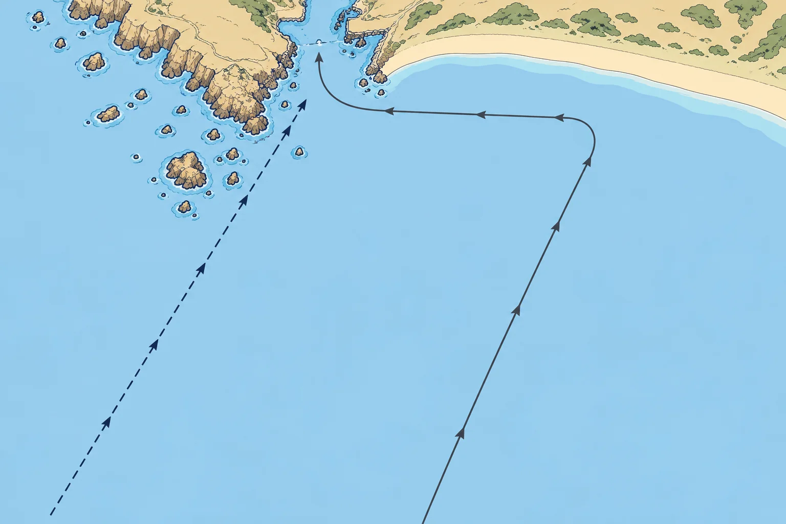
Aiming off means planning a landfall on a known safe side of your target. Choose an offset larger than estimated position and track errors, allowing for current and leeway, sideways drift from wind. Suppose a charted safe offshore landfall line, parallel to a straight coast, lies 30 NM ahead perpendicularly. A ground track, your path over the seabed, 10° from that perpendicular towards the safe side reaches the line about 30 × tan 10° ≈ 5.3 NM sideways. Confirm your position from safe water before turning along the coast.
Clearing lines and contours
A clearing line is a bearing or transit (two marks in line) marking a safe-water limit: stay on its safe side. A clearing depth is a minimum sounding, usable where the charted seabed gives reliable warning. Allow for tide, draught, a safety margin and the sounder’s reference point. A depth contour joins equal charted depths. Soundings can help check your approach, but the same depth can occur elsewhere and does not clear isolated hazards. Cross-check with other position information. See Pilotage for the method.
Lights' range
A light is visible out to the lesser of its luminous range, set by its brightness and the visibility, and its geographic range, set by heights. Geographic range in nautical miles ≈ 2.1 × (√ light height + √ eye height), heights in metres. A light 49 m high seen from an eye 2.25 m up: 2.1 × (7 + 1.5) ≈ 18 NM. Watch for it rising on the expected bearing.
Timing for daylight
A night landfall on a well-lit coast can be easier: lights identify themselves by their characteristics. Entering an unfamiliar or poorly lit harbour, or a coast with rocks, is best by daylight. Plan your speed so that you arrive with light, or stand off safely at sea until dawn. A rested crew is part of the timing.
2Key data
- Aim-off: perpendicular distance × tan(ground-track angle)
- 30 NM × tan 10° ≈ 5.3 NM; offset must exceed estimated errors
- Geographic range
- ≈ 2.1 × (√ light height m + √ eye height m) NM
- Visible range of a light
- The lesser of luminous and geographic range
- Spanish terms
- Recalada, alcance luminoso, alcance geográfico, veril
3Key points
- 1
Assess position uncertainty before landfall; plan an approach that tolerates it.
- 2
Aim off to a charted safe side; the offset must exceed estimated position and track errors. Confirm your position before turning.
- 3
A light shows at the lesser of its luminous and geographic range.
- 4
Arrive with daylight at an unfamiliar or rocky entrance, or stand off until dawn.
4Frequent mistakes
Wrong: Assume a fixed 10° aim-off guarantees which side you will reach.
Right: Choose a charted safe side and an offset larger than estimated position and track errors, allowing for current and leeway. Confirm your position from safe water before turning.
Wrong: A light with a 25 NM range will be seen at 25 NM.
Right: Its height and yours may limit it to less. Use the lesser of the luminous and geographic ranges.
5Practice case & exam keys
After 36 hours with no GNSS, your estimated position is 25 NM from a harbour that lies between a rocky headland to the north and a long sandy coast to the south. It will be dark in four hours. How do you plan the landfall?
Show the answer
Do not assume 10° is enough after 36 hours without GNSS. Choose a southern offshore landfall line only if charts and conditions show safe water. Make the offset exceed estimated position and track errors, allowing for current and leeway. Confirm your position independently before turning north. Check approach depths and light identities. Use your speed to recalculate arrival time. If daylight or reliable identification is doubtful, stand off in safe water until dawn.
Exam keys
- Aim-off: perpendicular distance × tan(ground-track angle); offset must exceed estimated position and track errors. Confirm position before turning.
- Clearing lines, clearing depths and depth contours on the approach.
- A light is seen at the lesser of luminous and geographic ranges.
- Time the arrival for daylight, or stand off until dawn.
Finish this unit
When you've read it, match the terms, then answer three questions. Get them all right to finish the unit; opening the page alone doesn't count.
My notes for this unit
No notes