

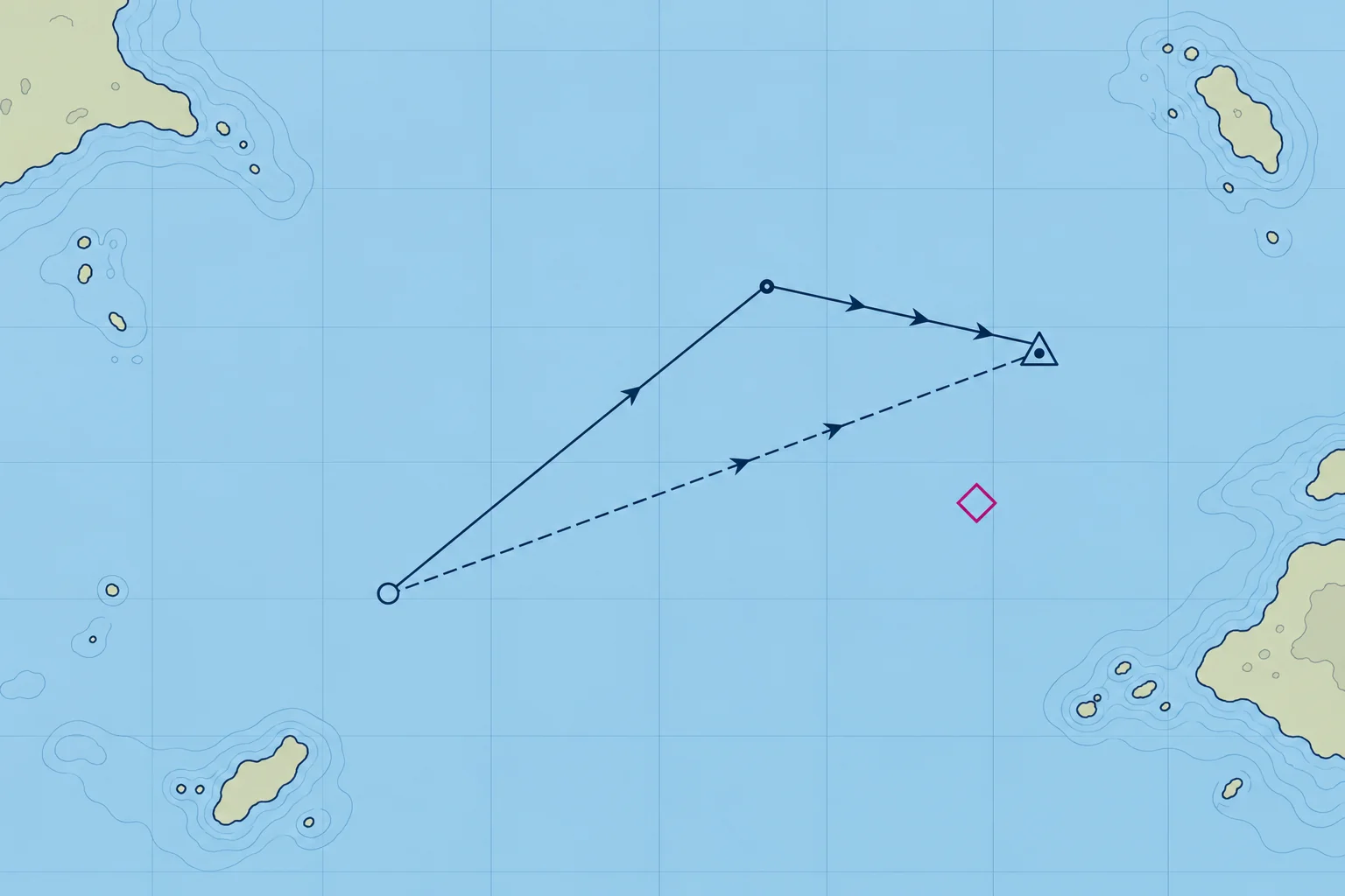
The estimated position: adding the tidal stream
1The lesson in plain words
An estimated position takes your water track and log distance and adds the tidal stream. It is your best position when you have no fix.
What an EP is
An estimated position (EP) is the best position you can work out without a fix. It starts like DR, along the water track for the log distance, and then adds the tidal stream: how far the water itself has carried the boat over the same time.
Set, rate and drift
A tidal stream has a set, the direction it flows towards, and a rate, its speed in knots. The distance it carries you in a given time is the drift: rate × time. You read set and rate from a tidal diamond on the chart or a tidal stream atlas for that hour of the tide (Tidal streams unit). A stream setting 090°T at 2 kn carries everything in the water 2 M east each hour.
Plotting it
From the start, plot the water track and log distance: one arrowhead. Add the stream set and drift for the same period: three arrowheads. Mark the EP with a triangle and time. Join the start to the EP: two arrowheads show the overall ground track; its length is distance made good. For a steady leg, divide this distance by elapsed hours for estimated speed over the ground (SOG). For changing tracks, calculate each leg separately.
Longer runs
Use the predicted stream for each hour and estimated location. You can add all water-track and stream lines to find the final EP, but the start-to-end line shows only net movement. If the track changes, plot each leg or hour separately. Add those ground distances before dividing by total hours for average SOG. For part of an hour, scale the drift: 30 minutes at 1.6 kn gives 0.8 M.
The opposite question
The EP answers "where am I now?" The reverse question, "which heading do I steer to make good a track?", needs a course to steer, taught in the Set and drift unit.
2Key data
- EP
- Water track and log distance + stream for the same time
- Set
- Direction the stream flows towards (°T)
- Drift
- Rate (kn) × time (h)
- EP symbol (RYA)
- Triangle round a dot, with the time
- Ground track
- Start to EP; two arrowheads
3Key points
- 1
EP = water track and log distance, plus the tidal stream for the same time.
- 2
Set is where the stream flows towards; drift is rate × time.
- 3
The line from the start to the EP shows the overall ground track and distance made good.
- 4
Add the stream hour by hour, each from the right diamond or atlas page.
4Frequent mistakes
Wrong: Plot the stream from the direction it comes from, as with wind.
Right: Set is the direction the stream flows towards. A stream setting 090°T carries you east.
Wrong: Use a full hour of stream for a 40-minute run.
Right: Scale it to the time: 40 minutes is two-thirds of the hourly drift.
Wrong: An EP is as good as a fix.
Right: It is built from several estimates. Fix as soon as you can.
5Practice case & exam keys
From a 15:00 fix you sail for 30 minutes along a water track of 260°T at 6.0 kn through the water. The stream sets 350°T at 1.6 kn. A crewmate adds 1.6 M of stream and reports the resulting distance as SOG. What needs correcting?
Show the answer
The run lasted half an hour: plot 3.0 M on 260°T, then 0.8 M on 350°T. The EP is about 3.1 M from the fix on 275°T. That is ground distance, not speed: estimated average SOG is 3.1 ÷ 0.5 ≈ 6.2 kn. Mark the EP and 15:30.
Exam keys
- EP = water-track line + tidal stream line for the same period.
- Set: the direction the stream flows towards; drift = rate × time.
- EP: a triangle with the time; ground track two arrowheads, stream three.
- SOG = ground distance ÷ elapsed hours.
Finish this unit
When you've read it, match the terms, then answer three questions. Get them all right to finish the unit; opening the page alone doesn't count.
My notes for this unit
No notes