

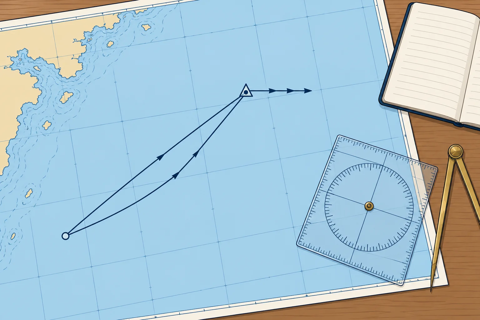
A worked estimated position, step by step
1The lesson in plain words
One hour of a real passage: magnetic heading, variation, leeway, log distance and tidal stream, taken in order to give an EP.
The data
At 10:00 you fix your position; the log reads 12.0. You steer 100°M. Variation is 2°W, and the deviation card shows none on this heading. The wind is from the north, and you estimate 5° of leeway. At 11:00 the log reads 18.0. The tidal diamond for that hour gives a set of 180°T and a rate of 1.5 kn.
Heading to water track
Convert to true: 100°M with 2°W variation is 098°T, because you subtract west going from magnetic to true. The north wind is on the port side, so it pushes you to starboard: add the leeway, 098 + 5 = 103°T. That is the water track. Distance through the water: 18.0 − 12.0 = 6.0 M.
Adding the stream
From the 10:00 fix, lay off 103°T and mark 6.0 M: one arrowhead. From that point, lay off 180°T and mark 1.5 kn × 1 h = 1.5 M: three arrowheads. The end of that line is the 11:00 EP. Draw the triangle and write 11:00 beside it.
Reading the result
Join the fix to the EP: the ground track is about 116°T and about 6.5 M long, so you made about 6.5 kn over the ground. The stream has carried you about 13° south of your water track. Log the EP with its time and log reading, then take a fix to check it.
Check the signs
Ask three questions every time. Did I apply variation the right way? Did leeway move the track downwind? Did I plot the stream towards its set, not from it? Most EP errors come from one of these.
2Key data
- Magnetic to true
- 100°M with 2°W variation = 098°T
- Leeway (wind on port)
- 098°T + 5° = 103°T water track
- Log distance
- 18.0 − 12.0 = 6.0 M
- Stream
- 180°T, 1.5 kn × 1 h = 1.5 M
- Result
- Ground track ≈ 116°T, ≈ 6.5 M in the hour
3Key points
- 1
Order: magnetic to true, then leeway, then log distance, then stream.
- 2
From magnetic to true, subtract west variation and add east.
- 3
Leeway moves the water track downwind; the stream is plotted towards its set.
- 4
The fix-to-EP line gives ground track and distance; divide distance by elapsed hours for estimated SOG.
4Frequent mistakes
Wrong: Add the 2°W variation to get true.
Right: From magnetic to true, subtract west: 100°M becomes 098°T, not 102°T.
Wrong: Plot the stream from 180°T, the direction it comes from.
Right: Plot it towards 180°T: a stream setting 180°T carries you south.
5Practice case & exam keys
On another day the data are the same, except that a southerly wind is on your starboard side, still with 5° leeway. A crewmate says the EP stays unchanged because the stream is unchanged. Do you agree?
Show the answer
No. The wind changes the water track to 093°T even though the stream stays the same. Wind on the starboard side pushes you to port: 098 − 5 = 093°T. Lay off 6.0 M along 093°T, then the stream 1.5 M towards 180°T. The EP falls about 1 M north of the first one, and the ground track is about 107°T, 6.3 M long.
Exam keys
- Steps: true heading, leeway to water track, log distance, stream.
- Magnetic to true: subtract west, add east.
- Wind on the port side: add leeway; on the starboard side: subtract.
- Plot the stream towards its set, for the same time.
Finish this unit
When you've read it, match the terms, then answer three questions. Get them all right to finish the unit; opening the page alone doesn't count.
My notes for this unit
No notes