

Gnomonic charts and great circles in practice
1The lesson in plain words
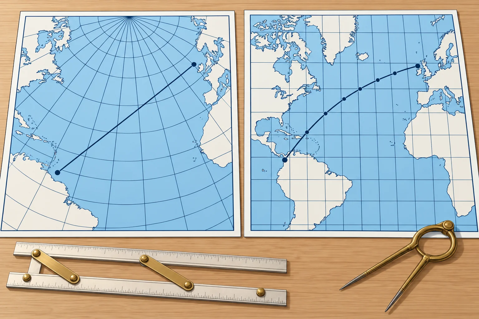
On a gnomonic chart every great circle is a straight line. Draw the route there, read off waypoints, and plot them on the Mercator chart.
The projection
A gnomonic chart projects the Earth from its centre onto a flat plane touching it at one point. Every great circle becomes a straight line. Distances and angles are distorted, more so away from the centre, so you do not measure courses or distances on it.
Using it
Draw a straight line between departure and destination: that is the great circle. Check that it clears land, ice and dangers. Read the latitude where it crosses every 5° or 10° meridian. Plot and join those waypoints on Mercator, then check every resulting rhumb-line leg for hazards.
Electronic route
Chart plotters, an Electronic Chart Display and Information System (ECDIS), and routeing software calculate great-circle routes directly and split them into legs. Check that every connecting leg clears land and hazards, that the legs are sensible, and that the route is what you meant. Keep a hand method as a cross-check.
Wind before geometry
Sailing yachts rarely follow the great circle on a trade-wind passage. On the Atlantic rally route, crews usually head south-west first to find the trade winds, then run west. The great circle is the yardstick for distance; the wind and current set the route (Navigation: ocean passage planning).
Spanish exams
The Spanish Capitán de Yate syllabus includes great-circle sailing (navegación ortodrómica) among its navigation calculations. Practise distance, initial course, vertex and waypoints by hand, checking every sign and quadrant.
2Key data
- Gnomonic chart
- Projected from the Earth's centre; great circles are straight
- Do not measure
- Courses or distances on a gnomonic chart
- Transfer
- Read waypoints every 5° or 10° of longitude onto Mercator
- Electronic
- Plotters and ECDIS compute great-circle legs; check them
- Sailing practice
- Wind and current decide; the great circle is the yardstick
3Key points
- 1
On a gnomonic chart every great circle is a straight line.
- 2
Draw the route there, read waypoints, transfer them to the Mercator chart.
- 3
Never measure courses or distances on a gnomonic chart.
- 4
Electronic great-circle routes still need checking against land, ice and hazards.
4Frequent mistakes
Wrong: Measure the course to steer with a protractor on the gnomonic chart.
Right: Angles are distorted on a gnomonic chart. Use it for the track, then work courses on the Mercator chart or by calculation.
Wrong: A plotter's great-circle route is safe because the computer drew it.
Right: The plotter calculates geometry, not seamanship. Check every leg against land, ice and other hazards.
5Practice case & exam keys
Your gnomonic great circle clears a danger, but one straight Mercator leg between transferred waypoints crosses it. Can you use that route?
Show the answer
No. You will sail the connecting legs. Add or move waypoints to clear the danger, then recheck every leg on Mercator. A clear great-circle curve does not guarantee clear legs.
Exam keys
- Gnomonic chart: great circles are straight lines; courses and distances distorted.
- Method: straight line on gnomonic → waypoints → Mercator rhumb-line legs.
- Electronic great-circle routes must be checked for land, ice and hazards.
- Yachts: wind and current set the route; the great circle is the yardstick.
Finish this unit
When you've read it, match the terms, then answer three questions. Get them all right to finish the unit; opening the page alone doesn't count.
My notes for this unit
No notes