Decide
Four situations at sea. Decide first, then read why.
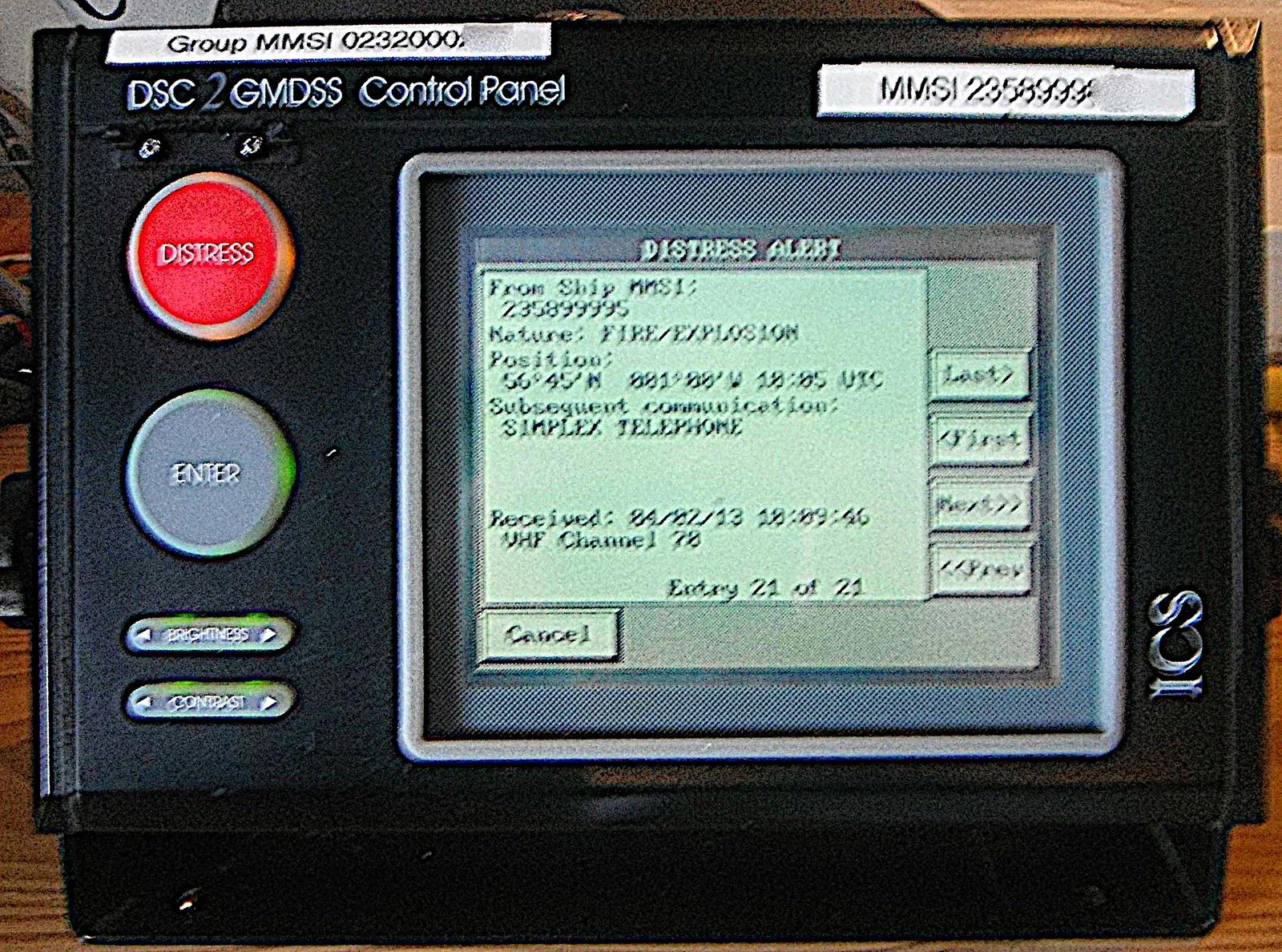
Your DSC panel shows a distress alert from a ship 6 miles away. You are in sea area A1. First?
Key points
- Sea areasA1 VHF, A2 MF, A3 satellite, A4 the rest.
- All ships: VHF DSC ch 70 watch, SART, NAVTEX, 406 MHz EPIRB.
- 500 GT+: a SART each side, three two-way VHFs.
- Rules in SOLAS chapter IV.
- Channels70 DSC only; 16 distress and calling; 13 bridge to bridge; 6 intership and SAR.
- MMSI: nine-digit DSC identity.
- Keep GNSS linked to the DSC controller.
- Move off 16 to a working channel.
- Priorities and proceduresMAYDAY > PAN PAN > SECURITE.
- Distress on the master's authority: DSC alert, then voice on 16.
- False alert: reset and cancel by voice, log it.
- Received alert: listen, call the master, plot, log.
- EPIRB, SART, NAVTEXEPIRB 406 MHz; SART 12 dots on X-band; NAVTEX 518 kHz in English.
- EPIRB float-free, check expiry dates.
- SART dots become arcs and circles close in.
- Record tests in the radio log.
Check what you have read
A ship sails only within range of shore-based VHF DSC stations. Which GMDSS sea area is it in?
Worked case: A DSC distress alert on the 0000–0400 watch
0215 UTC, sea area A1, 20 miles off a coast with a VHF coast station. The DSC controller alarms: distress alert received on channel 70 from a fishing vessel's MMSI, nature "flooding", position about 6 miles south-west of you.
Before you read the solution: what would you do?
True or false?
Decide each statement before you see the answer.
If I send a false alert, I'll just switch the radio off.
Sea area A3 is the polar regions.
EPIRB 406 MHz; SART 12 dots on X-band; NAVTEX 518 kHz in English.
The EPIRB alerts by 121.5 MHz.
MAYDAY > PAN PAN > SECURITE.
70 DSC only; 16 distress and calling; 13 bridge to bridge; 6 intership and SAR.
PAN PAN is for weather warnings.
I can talk to another ship on channel 70.
On receiving a DSC distress alert, I must acknowledge it by DSC at once.
A1 VHF, A2 MF, A3 satellite, A4 the rest.
Exercise: Radio decisions
Channels, priorities and the order of a distress call.
Step by step
You want to call a nearby ship about a crossing. Which channel?
A crew member has a serious injury and you need medical advice. Which priority?
Put the MAYDAY message in order (after the call).
- 1Other information (persons on board, intentions)
- 2Assistance required
- 3MAYDAY and the ship's name, call sign and MMSI
- 4Nature of distress
- 5Position
On which VHF channel do you cancel a false VHF DSC distress alert by voice?
Now on your own
Now on your own.
How many dots does a radar SART show on the screen when the rescuer is still far off?
Your ship is 150 miles offshore, out of VHF coast-station range but within MF DSC range. Which sea area?
Which NAVTEX message types must never be deselected?
Where should a float-free EPIRB be mounted?
Check: 10 questions
Questions from this subject, explained after each answer.
Free: lesson + 10 questions · Exam Pass: all 27 questions, unlimited practice tests, your mistakes retrained
The full explanation and the lessons for each programme item
Topic 1 of 5
Sea areas decide the equipment
SOLAS chapter IV divides the sea into four GMDSS areas.
A1: within range of at least one VHF coast station with continuous DSC alerting. A2: outside A1, within range of an MF coast station with continuous DSC alerting. A3: outside A1 and A2, within the coverage of a recognised mobile satellite service. A4: everywhere else.
Every ship carries VHF with DSC on channel 70 and voice on channels 6, 13 and 16, a continuous DSC watch on channel 70, a radar SART or AIS-SART, receivers for maritime safety information (such as NAVTEX), and a float-free 406 MHz EPIRB. Ships going further add MF, HF or satellite equipment.
Ships of 500 GT or more carry a SART on each side and three two-way VHF sets for survival craft; cargo ships of 300 to 500 GT carry at least one SART and two two-way VHF sets.
- A1 = VHF, A2 = MF, A3 = satellite, A4 = polar regions beyond satellite cover (HF).
- A deck officer's certificate requires a GMDSS operator certificate (usually the GOC).
Topic 2 of 5
Which channel for what
VHF channel 70 (156.525 MHz) is for DSC only: never speak on it. Channel 16 (156.8 MHz) is for distress, urgency and safety calls by voice, and for calling.
Channel 13 is for bridge-to-bridge navigation safety. Channel 6 is for intership and on-scene search and rescue communication.
A DSC call is a short digital message: it alerts or calls a station, then you talk on the voice channel it names. A distress alert gives your MMSI, position, time and, if you set it, the nature of distress.
Use standard phrases (IMO SMCP) and keep calls short. On channel 16, after calling, move to a working channel.
- MMSI: the nine-digit identity of a ship's DSC equipment.
- Keep the GNSS feed to the DSC controller working, or enter the position manually: a distress alert without a position is much harder to act on.
Topic 3 of 5
Distress, urgency, safety, and false alerts
MAYDAY (distress) is for grave and imminent danger needing immediate help.
PAN PAN (urgency) is for a very urgent message about the safety of a ship or person, for example a medical emergency. SECURITE (safety) is for navigational or weather warnings.
Sending a distress alert, on the master's authority: press the distress button (lifting the cover) for about five seconds, or use the menu to add the nature of distress; then wait briefly and send the MAYDAY call and message by voice on channel 16. The message gives MAYDAY, the ship's name, call sign and MMSI, position, the nature of distress, the help wanted, and other useful facts, such as the number of persons on board.
If a distress alert is sent by mistake, reset the equipment at once and cancel by voice on the associated channel (channel 16 for VHF): "All stations" three times, the ship's name, call sign and MMSI, and "cancel my distress alert of (date, time UTC)". Never switch the set off to hide it. Log it.
- A ship receiving a VHF DSC distress alert: listen on channel 16, inform the master, plot the position. Acknowledging by DSC is normally left to coast stations and rescue centres.
- If the ship in distress is nearby and no coast station answers, acknowledge by voice on channel 16 and inform a coast station or rescue coordination centre (RCC) by any means.
Topic 4 of 5
EPIRB, SART, NAVTEX and the radio log
The EPIRB sends its distress alert on 406 MHz to the COSPAS-SARSAT satellites, which pass it to a rescue coordination centre.
Many also transmit on 121.5 MHz for homing. It is float-free: it releases and activates by itself if the ship sinks.
A radar SART answers a 9 GHz (X-band) radar pulse. On the rescuer's screen it shows as a line of 12 dots outward from its position; when the rescuer gets close, the dots become arcs and then circles. An AIS-SART shows on AIS as a SART target.
NAVTEX receives navigational and weather warnings on 518 kHz in English, with a designed range of about 400 miles. Select the right stations and message types, and never deselect navigational warnings, meteorological warnings and SAR information.
- Test equipment as required (for example the daily DSC self-test without radiating), check battery and hydrostatic release expiry dates, and record tests in the GMDSS radio log.
- Distress, urgency and safety traffic is recorded in the radio log with the UTC time.
Topic 5 of 5
Practise and go further
The best places to practise this subject. When you finish, one tap brings you back to the course.
- Radio simulatorSimulator
- GMDSS quizQuiz
- GMDSS basics and sea areasLesson
- VHF and DSCLesson
- DSC in depthLesson
- SMCPLesson
All lessons by programme item
- 7.1 GMDSS sea areas and the equipment a ship carries (SOLAS chapter IV)
- 7.2 VHF channels and digital selective calling (DSC)
- 7.3 Distress, urgency and safety procedures, and false alerts
- 7.4 EPIRB, SART and NAVTEX; tests and the radio log
Sources
Checked against the public standards on .