
Astronomy and celestial navigation · Level R5 · 5 parts · about 13 min
The noon sight: latitude by the Sun
5 short parts: Local noon · Observing · The rule · Worked · Limits. Each part explains the idea, then gives the points to remember, the common mistakes, a worked case and a practice question; the Academy unit adds all 30 check questions.
1 · Local noon
Predicting the time of local noon
At local noon the Sun crosses your meridian. Latitude needs simple addition or subtraction. Predict noon from Mer. Pass. and your longitude.

Why noon
When the Sun crosses your meridian, it bears due north or south. The celestial triangle's three points—the pole (P), your zenith directly overhead (Z), and the Sun (X)—lie on your meridian. Latitude follows by adding or subtracting, without reduction tables. The noon sight uses the Sun's meridian altitude, its height at passage. On a slow yacht, the highest altitude is a close approximation.
The time
Take Mer. Pass. from the daily page: the LMT of the Sun's meridian passage, to the minute. Add west longitude in time, or subtract east, for the UT of meridian passage at your longitude. Convert to the ship's clock with the zone description (Celestial: time and the almanac; Navigation: Polaris and time).
Worked
26 November 2026, DR at noon 21°10′N 027°45′W. Mer. Pass. 1147. Longitude 27°45′ = 1h 51m, west: 1338 UT. With zone description +2 the ship's clock reads 1138. Dec for 1338 UT: at 13h S 20°59.9′, d 0.5, increasing; +0.3′ for 38 minutes gives S 21°00.2′.
A moving vessel
Use the longitude you expect at noon, not the morning one. Each 15′ of longitude you make westward makes noon 1 minute later; eastward, earlier. Be ready about 10 minutes before the predicted time: that covers a small error in the DR longitude.
Dec at noon
The Sun's declination changes by at most about 1′ an hour, so take Dec for the noon UT with the d correction. A 4-minute error in the time changes Dec by less than 0.1′. Latitude by the noon sight does not depend on accurate time.
Key figures
- Mer. Pass.
- LMT of the Sun's meridian passage, to the minute
- UT of local noon
- Mer. Pass. + W long in time (− E)
- Worked
- 1147 + 1h 51m = 1338 UT; ZT 1138 (zone description +2)
- Moving west
- Each 15′ of longitude west: noon 1 min later
- Dec at noon
- S 21°00.2′ at 1338 UT, 26 Nov 2026
- Spanish terms
- Meridiana, paso del Sol por el meridiano, altura meridiana
Remember
- At local noon the Sun bears due N or S: latitude by simple arithmetic.
- UT of noon = Mer. Pass. + W long in time (− E).
- Use the DR longitude expected at noon.
- Take Dec for the noon UT; exact time is not critical.
Common mistakes
Wrong: Local noon is at 1200 on the ship's clock.
Right: Work it out from Mer. Pass. and longitude: 1138 ZT in the worked example.
Wrong: Use the declination for 1200 UT.
Right: Use Dec for the UT of your noon, 1338 UT here; in the Atlantic that can be hours from 1200 UT.
Worked case
On 13 May 2026, heading for the Azores, your DR for noon is 37°50′N 035°20′W, zone description +2. The daily page gives Mer. Pass. 1156; Sun Dec at 14h N 18°28.6′, d 0.6, increasing. Your mate plans to start observing at 1230 ZT. What start time and Dec would you choose?
Show the answer
Noon is about 1417 UT, or 1217 ZT. Start around 1207 ZT, about ten minutes beforehand; 1230 is too late. At 1417 UT, the increasing Dec gains about 0.2′, giving N 18°28.8′.
Practice question
Mer. Pass. is 1156 and your noon DR longitude is 035°20′W. At about what UT is local noon?
- 1156
- 0935
- 1417
- 1435
Show the answer
Answer: C. 35°20′ is 2h 21m 20s in time, west, so add: about 1417 UT.
2 · Observing
Observing the meridian altitude
On a slow yacht, follow the Sun up and read its highest altitude as it starts to fall. Note whether it bears north or south.
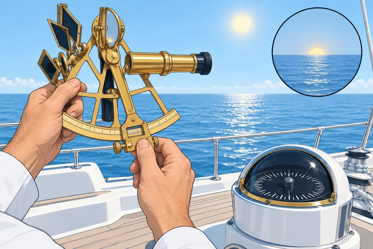
The Sun hangs
Near noon the Sun's altitude changes very slowly: for a few minutes it seems to stop. Follow it up and read the maximum as it starts to fall. On a slow yacht, this highest sextant reading Hs closely approximates the meridian altitude, the altitude at meridian passage. You do not need the exact moment for this approximation.
A moving vessel
Motion north or south can shift the maximum several minutes before or after meridian passage. On a slow yacht, the altitude difference is usually small, so the maximum is a practical approximation. On a fast north–south run, observe at the computed time of meridian passage.
Name of the bearing
Note whether the Sun bore south or north of you. In northern mid-latitudes it bears south; in the tropics, it can bear north. This name decides the arithmetic in the next part. A glance at the compass is enough.
If you miss it
If cloud hides the Sun at noon, a sight a few minutes either side can still be used, as an ex-meridian sight or a normal intercept sight (Celestial: sight reduction). For those, the time to the second matters again.
Key figures
- Start
- About 10 min before predicted noon
- Meridian altitude
- Altitude at meridian passage; close to a slow yacht's maximum
- Time
- Exact time not critical on a slow yacht; log it anyway
- Bearing
- Note N or S: it names the zenith distance
- Fast vessel
- Observe at the computed time of meridian passage
- Spanish terms
- Altura meridiana, altura máxima, meridiana
Taking the noon sight on a slow yacht
- Start about 10 minutes before predicted noon. — Allow for a small DR longitude error.
- Follow the Sun’s altitude as it rises. — Look for the highest reading.
- Keep observing while the altitude seems unchanged. — The Sun may hang for a few minutes.
- When the Sun's altitude clearly starts decreasing, record the highest sextant reading reached. — On a slow yacht, the maximum closely approximates meridian altitude.
- Record the Sun’s bearing, N or S, and the time. — You need the bearing for latitude and the time for declination.
Remember
- On a slow yacht, follow the Sun up; read when it starts to dip.
- On a slow yacht, the maximum closely approximates the meridian altitude.
- Note whether the Sun bore north or south.
- Fast vessels: observe at the computed time instead.
- Missed it? Use an ex-meridian or intercept sight.
Common mistakes
Wrong: On a slow yacht, take one sight at the predicted minute and leave it.
Right: Follow the Sun until it stops rising and dips; on a slow yacht, the maximum closely approximates meridian altitude.
Wrong: The Sun always bears south at noon in the northern hemisphere.
Right: In the tropics, when Dec is north and greater than your latitude, it bears north.
Worked case
On a slow yacht approaching predicted noon, the Sun's altitude creeps up, stays the same for about three minutes, then starts to fall. A crew member wants to wait for the exact time from the almanac before reading. What do you advise?
Show the answer
Read the highest altitude reached as the Sun starts to fall. On a slow yacht, this maximum closely approximates meridian altitude. The exact time is not critical for this approximation. Note the bearing, north or south, and log the time. Waiting risks cloud or a bad horizon.
Practice question
On a slow yacht, when do you read the maximum altitude for a noon sight?
- At exactly 1200 zone time
- When the Sun starts to dip
- As soon as the Sun first appears
- Ten minutes after Mer. Pass.
Show the answer
Answer: B. Read the highest altitude as the Sun starts to fall. On a slow yacht, this maximum closely approximates meridian altitude.
3 · The rule
Latitude from the meridian altitude
Zenith distance plus declination, with names: add for the same name, subtract for contrary names. One rule covers every case.
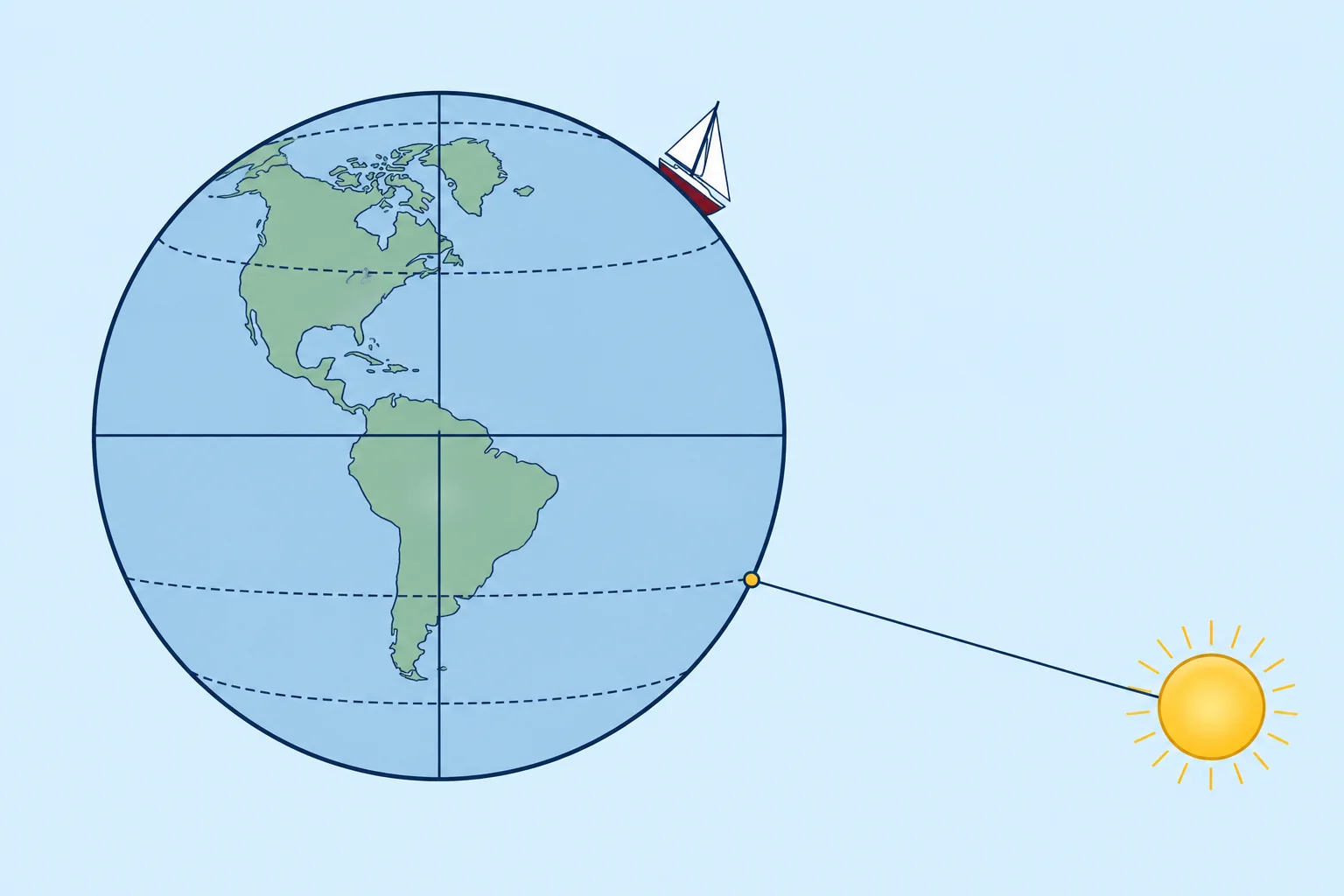
Zenith distance
First correct Hs to Ho (Celestial: the sextant). Your zenith is the point directly overhead. The zenith distance, ZD = 90° − Ho, is the angle from your zenith to the Sun. Name ZD opposite to the Sun's bearing: Sun south means ZD north; Sun north means ZD south.
The rule
Your latitude is the zenith distance combined with the declination, by name. Same names: latitude = ZD + Dec. Contrary names: latitude = the difference, named like the larger. Spanish courses write it latitud = distancia cenital ± declinación.
Same name
At about 38°N in May, with Dec N 18°, the Sun bears south, so ZD is named N, like Dec: add. This is the usual case in summer in your own hemisphere.
Contrary names
At about 21°N in November, with Dec S 21°, the Sun bears south: ZD named N, Dec named S. Subtract and name the result like the larger, here ZD: latitude N. You and the point directly beneath the Sun are on opposite sides of the equator.
Polar side
In the tropics, when Dec has your latitude's name but is larger, the Sun passes on the polar side of your zenith. At about 11°N with Dec N 18°, it bears north: ZD named S, Dec N, contrary names. Latitude = Dec − ZD, named N, like the larger Dec. The rule has not changed; only the bearing has.
Accuracy
Each 1′ of error in Ho gives 1 M of error in latitude. A good yacht noon sight is usually within about 1–2 M.
Key figures
- Zenith distance
- ZD = 90° − Ho, named opposite to the Sun's bearing
- Same names
- Latitude = ZD + Dec
- Contrary names
- Latitude = difference, named like the larger
- Polar side
- Dec > latitude, same hemisphere: Sun bears to the pole
- Accuracy
- 1′ of altitude error = 1 M of latitude
- Spanish terms
- Latitud = distancia cenital ± declinación
Remember
- ZD = 90° − Ho, named opposite to the Sun's bearing.
- Same names: add. Contrary names: subtract, name like the larger.
- Polar-side Sun: ZD and Dec contrary; latitude = Dec − ZD.
- 1′ of altitude = 1 M of latitude.
Common mistakes
Wrong: Name ZD after the Sun's bearing: Sun south, ZD south.
Right: Name it the opposite way: you are north of a Sun that bears south, so ZD is N.
Wrong: Use 90° − Hs as the zenith distance.
Right: Correct Hs to Ho first, using the corrections for your observation (Celestial: the sextant). Then calculate 90° − Ho.
Wrong: Contrary names mean latitude = Dec − ZD.
Right: Take the difference and name it like the larger. Usually ZD is larger and keeps its name.
Worked case
On 13 May 2026 near 035°20′W in the tropical Atlantic, your DR is about 11°N. At noon, Ho is 82°30.0′, Dec N 18°28.8′ and the Sun bears north. Your mate adds ZD to Dec and gets 25°58.8′N. Would you accept this? Explain and calculate your latitude.
Show the answer
ZD = 90° − 82°30.0′ = 7°30.0′. The Sun bears north, so ZD is named S. Dec is N: contrary names, subtract and name like the larger. Latitude = 18°28.8′ − 7°30.0′ = 10°58.8′N. Reject the addition: ZD and Dec have contrary names. The result also agrees closely with the DR.
Practice question
At noon the Sun bears south. How is the zenith distance named?
- South, like the Sun's bearing
- North, opposite the bearing
- The same name as declination
- The same name as longitude
Show the answer
Answer: B. If the Sun bears south, you are north of the latitude directly beneath it, so ZD is N.
4 · Worked
Two noon sights, worked
One November sight with contrary names off West Africa and one May sight with the same name near the Azores, both from real 2026 almanac values.
Example 1: the data
26 November 2026, DR 21°10′N 027°45′W, bound west. Noon at 1338 UT. Sun lower limb, meridian Hs 47°31.4′, Sun bearing south. IE 1.8′ off the arc, height of eye 2.5 m. Dec at 1338 UT: S 21°00.2′.
Example 1: the answer
Ho = 47°45.8′, as corrected in the sextant unit. ZD = 90° − 47°45.8′ = 42°14.2′, named N because the Sun bears south. Dec S: contrary names, subtract: 42°14.2′ − 21°00.2′ = 21°14.0′N. The DR was 21°10′N: you are 4 M north of it.
Example 2: the data
13 May 2026, DR 37°50′N 035°20′W, bound for the Azores. At meridian passage, the Sun bears south. Corrected altitude Ho is 70°42.8′; declination is N 18°28.8′.
Example 2: the answer
ZD = 90° − 70°42.8′ = 19°17.2′, named N. Dec N: same name, add: 19°17.2′ + 18°28.8′ = 37°46.0′N, 4 M south of the DR. The US Naval Observatory's online almanac computes altitudes of 47°45.8′ and 70°42.8′ at these latitudes, a check on both examples.
Using it
The noon latitude is a position line running east–west. It tells you how far north or south you are, but does not give longitude. Historically, navigators reached an island's latitude, then sailed east or west along it: running down the latitude.
Key figures
- Example 1 data
- 26 Nov 2026: Ho 47°45.8′, Sun S, Dec S 21°00.2′
- Example 1 latitude
- ZD 42°14.2′ N − Dec 21°00.2′ S = 21°14.0′N
- Example 2 data
- 13 May 2026: Ho 70°42.8′, Sun S, Dec N 18°28.8′
- Example 2 latitude
- ZD 19°17.2′ N + Dec 18°28.8′ N = 37°46.0′N
- Position line
- The noon latitude runs east–west
Remember
- Ex. 1 (contrary): 42°14.2′ N − 21°00.2′ S = 21°14.0′N.
- Ex. 2 (same name): 19°17.2′ N + 18°28.8′ N = 37°46.0′N.
- Always name ZD from the Sun's bearing before combining.
- The noon latitude is an east–west position line.
Common mistakes
Wrong: In November off Africa, add Dec because both latitude and ZD are north.
Right: Compare ZD with Dec: ZD N, Dec S, contrary, so subtract.
Wrong: A noon sight gives a full fix.
Right: It gives latitude only, an east–west position line. For methods of combining position lines, see Celestial: sight reduction.
Worked case
On 26 November 2026 your mate works the noon sight and gets 63°14.4′N. The DR is 21°10′N. Find the mistake and the right answer, using Ho 47°45.8′ and Dec S 21°00.2′.
Show the answer
63°14.4′ is ZD + Dec: the mate added a south Dec to a north ZD. ZD = 42°14.2′, named N because the Sun bore south; Dec is S, contrary, so subtract: 42°14.2′ − 21°00.2′ = 21°14.0′N. That agrees with the DR within 4 M, a further check.
Practice question
Example 1 gave 21°14.0′N against a DR of 21°10′N. Where is the boat relative to the DR?
- 4 M south of the DR
- 14 M north of the DR
- 4 M north of the DR
- Exactly on the DR
Show the answer
Answer: C. 21°14.0′ − 21°10.0′ = 4′ of latitude, north: 4 M.
5 · Limits
Limits and good practice
The noon sight is simple and robust, but it gives latitude only, needs a clean horizon and becomes awkward when the Sun is nearly overhead.

Very high altitudes
When your latitude is close to the declination, the Sun passes almost overhead, above about 85°. Its altitude then rises and falls quickly near noon and its bearing swings fast, so it is hard to keep the sextant vertical and catch the maximum. Take extra care, or use timed sights instead (Celestial: sight reduction).
Horizon and cloud
Everything rests on a sharp horizon below the Sun. Haze, a big swell or a low eye in breaking seas can give errors of several minutes. If cloud hides noon, use an ex-meridian or intercept sight a few minutes either side.
Latitude only
The noon sight gives latitude, nothing more. Longitude from the time of the maximum is rough: the Sun hangs for minutes, and each minute of time is 15′ of longitude. For a fix, cross the noon latitude with another position line.
Common errors
ZD named the wrong way; the wrong Dec name or day; 90° − Hs instead of Ho; assuming local noon is 1200 on the clock; reading too early because a wave lifted the horizon. Compare with the DR: a large difference is a reason to recheck the working, not to trust it blindly.
At twilight
In the northern hemisphere, Polaris offers a simple latitude check. See Celestial: stars, planets and the Moon for the method.
Key figures
- Above about 85°
- Altitude and bearing change fast: hard to observe
- Gives
- Latitude only
- Longitude from timing
- Rough: 1 min of time = 15′ of longitude
- Check
- Compare with the DR; recheck large differences
- At night
- Latitude by Polaris (stars-planets unit)
Remember
- Above about 85° the noon sight becomes awkward.
- A sharp horizon matters more than anything else.
- Noon gives latitude only; longitude from timing is rough.
- Check the result against the DR, and recheck big differences.
Common mistakes
Wrong: The time of the maximum gives an accurate longitude.
Right: The Sun hangs for minutes; 1 minute of time is 15′ of longitude. Use timed sights for longitude.
Wrong: A latitude far from the DR must be right because it is a sight.
Right: Recheck the sight’s names, date and corrections first. The DR can also be wrong; a large difference does not tell you which result to trust.
Worked case
Crossing the Atlantic in late June at about 23°N, a crew member wants to rely on the noon sight alone for position. The Sun's Dec is about N 23°26′. What problems do you foresee, and what do you do?
Show the answer
The Sun passes almost overhead, so its bearing swings quickly and the maximum is awkward to observe. Even a good noon sight gives latitude only. Keep the DR current. For alternative observations and how to combine position lines on a moving vessel, see Celestial: sight reduction.
Practice question
When is a noon sight hardest to take well?
- When the Sun is about 40° high
- When the Sun is nearly overhead
- When Dec is contrary to latitude
- When the sea is calm and clear
Show the answer
Answer: B. Near 90° the altitude and bearing change quickly, making the maximum hard to catch.