
Meteorology · Level R5 · 6 parts · about 22 min
Tropical revolving storms: seasons, signs and avoidance
6 short parts: What they are · Basins, seasons · Warning signs · Semicircles · Avoiding action · NHC, JTWC, 34 kt. Each part explains the idea, then gives the points to remember, the common mistakes, a worked case and a practice question; the Academy unit adds all 42 check questions.
1 · What they are
What a tropical revolving storm is and how it forms
A tropical revolving storm is an intense low fed by a warm ocean. Learn its names, its wind categories and what it needs to form.

Names and categories
A tropical cyclone, also called a tropical revolving storm (TRS), is an intense low-pressure system over warm tropical seas. Its strength is its maximum sustained wind; US advisories use a 1-minute mean. In those advisories, a tropical depression has winds up to 33 knots; a tropical storm has 34–63 knots and gets a name. At 64 knots or more it is a hurricane in the Atlantic and eastern and central North Pacific, and a typhoon in the north-west Pacific. Other basins use regional labels and wind-averaging periods.
The Saffir-Simpson scale
Hurricanes are graded on the Saffir-Simpson Hurricane Wind Scale: category 1 is 64–82 knots, 2 is 83–95, 3 is 96–112, 4 is 113–136 and 5 is 137 knots or more. Category 3 and above is a major hurricane. The scale counts only peak wind. A large category 1 storm can spread rough seas over a far wider area than a small category 4.
Structure
Winds spiral in towards the centre: anticlockwise in the northern hemisphere, clockwise in the southern. A well-developed cyclone may have a calm eye, typically a few tens of kilometres across, ringed by the eyewall, where the strongest winds and heaviest rain are. Rain bands spiral outwards. Hurricane-force winds may reach about 20 nautical miles from the centre of a small storm and over 150 in a large one; tropical-storm-force winds reach much further.
What it needs to form
Most storms form between about 5° and 30° of latitude, from a pre-existing disturbance such as a tropical wave: a trough drifting west in the trade winds. They usually develop over seas of at least 26.5 °C, with warm water about 60 m deep. Other ingredients are low vertical wind shear (little change of wind with height), moist air and enough Coriolis effect, the turning force of Earth's rotation. That is why they almost never form within about 5° of the equator.
Life and death
A storm's strengthening rate varies widely. Rapid intensification, 30 knots or more in 24 hours, is hard to forecast. Storms weaken over cooler water, over land or in strong shear. Many become extratropical at higher latitudes: their core loses its warmth relative to surrounding air. Dangerous winds and seas can remain as the storm accelerates.
Key figures
- Tropical depression
- Maximum sustained wind 33 kn or less
- Tropical storm
- 34–63 kn; receives a name
- Hurricane / typhoon
- 64 kn or more (1-minute mean in US advisories)
- Major hurricane
- Category 3 or more: 96 kn and above
- Sea temperature to form
- Usually ≥26.5 °C, with warm water about 60 m deep
- Rapid intensification
- Increase of 30 kn or more in 24 hours
Remember
- US advisories use 1-minute means: depression ≤33 kn; tropical storm 34–63 kn; hurricane ≥64 kn.
- Northern hemisphere storms turn anticlockwise; southern hemisphere storms turn clockwise.
- Typical formation conditions: warm sea (26.5 °C or more), low shear, moist air, a disturbance and Coriolis.
- The Saffir-Simpson category measures peak wind only, not the size of the storm.
- Storms that become extratropical can stay dangerous and often speed up.
Common mistakes
Wrong: A category 1 hurricane is always less dangerous to a vessel than a category 4.
Right: Category counts only peak wind. A big category 1 can cover a much larger area with gales and high seas.
Wrong: Tropical storms form right on the equator, where the sea is warmest.
Right: They need the Coriolis effect, which is usually too weak within about 5° of the equator.
Wrong: Once a storm is called extratropical, the danger is over.
Right: The name changes, not the marine danger. Extratropical storms can stay large and violent and often accelerate.
Worked case
In September, east of the Caribbean, the advisory describes a system with maximum sustained winds of 60 knots, a well-defined circulation and a sea surface temperature of 29 °C. Another crew member says it is ‘only a tropical storm’. How do you classify it, and what could happen next?
Show the answer
At 60 knots it is a tropical storm, close to the 64-knot hurricane threshold. Warm water, the peak of the Atlantic season and a well-organised circulation favour strengthening, possibly rapid. Treat it as a storm that may become a hurricane within a day and plan to keep well clear of its whole wind field, not just its centre.
Practice question
In a US advisory, a cyclone has maximum sustained 1-minute winds of 50 knots. What is its classification?
- A tropical depression
- A tropical storm
- A category 1 hurricane
- A tropical wave
Show the answer
Answer: B. US advisories use 1-minute means: a tropical storm has 34–63 knots, a depression ≤33 knots, and a hurricane ≥64 knots.
2 · Basins, seasons
Storm basins, seasons and typical tracks
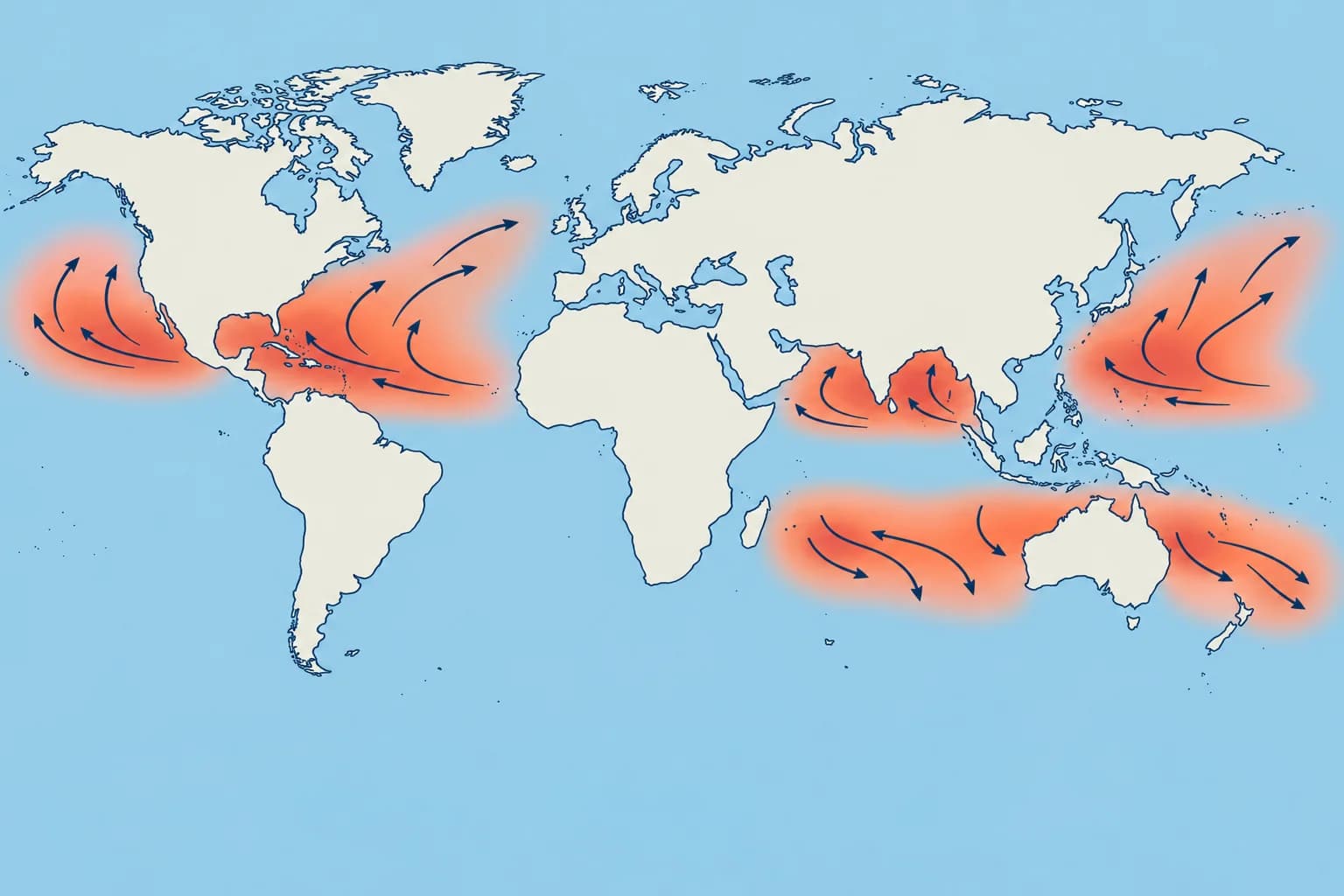
Each ocean basin has its own storm season. Know the dates for your route, and remember that storms can also form outside them.
Where and when
Tropical cyclones form in several basins, mostly in the late summer and early autumn of their hemisphere, when the sea is warmest. Season dates and usual activity windows are not guarantees: in some years Atlantic storms form in May or December. The South Atlantic and the south-east Pacific are almost free of them, because of cool water and strong shear. Only one hurricane is on record in the South Atlantic, off Brazil in 2004.
Northern hemisphere
North Atlantic, with the Caribbean and the Gulf of Mexico: 1 June to 30 November, with a sharp peak in September; 96 % of major hurricanes come between August and October. North-east Pacific: 15 May to 30 November. Central Pacific: 1 June to 30 November. North-west Pacific: all year, most active from July to November. North Indian Ocean: two main activity peaks, April–May and October–November, either side of the summer monsoon.
Southern hemisphere
The Mariner’s Guide gives these broad activity windows: South-west Indian Ocean: 15 November to 30 April, peaking from January to early March. South-east Indian Ocean and Australia: late October to May. South-west Pacific: late October to early May, peaking in late February and early March. The danger is in the southern summer: the mirror of the northern seasons.
How they move
In the tropics most storms move westwards, steered by the subtropical high, the belt of high pressure near 30° of latitude. Many then recurve: they turn poleward and then east, often speeding up. A typical forward speed is 13–17 knots, but a storm can stall for a day or race at over 25 knots after recurving. Southern hemisphere storms usually head south-west, then recurve to the south-east.
Using climatology
Climatology is the record of what usually happens. NHC's climatology pages, pilot charts and routeing charts show storm tracks and frequencies month by month. The Ocean passage planning unit uses these seasons to time a crossing; this part only gives the dates and the usual tracks.
Key figures
- North Atlantic
- 1 June – 30 November; sharp peak in September
- North-east Pacific
- 15 May – 30 November
- North-west Pacific
- All year; most active July – November
- North Indian Ocean
- Peaks in April–May and October–November; storms possible all year
- South-west Indian Ocean
- 15 November – 30 April
- Australia and south-west Pacific
- Late October – May (south-west Pacific to early May)
Remember
- North Atlantic season: 1 June to 30 November, sharply peaking in September.
- The north-west Pacific has typhoons in every month; most come from July to November.
- The north Indian Ocean peaks in April–May and October–November; storms can occur outside these peaks.
- Southern hemisphere seasons run through the southern summer, roughly November to April.
- Storms usually track west, then recurve poleward and east, often speeding up.
Common mistakes
Wrong: After 30 November the Atlantic is guaranteed to be free of storms.
Right: The dates frame the usual season. Storms occasionally form in May or December, so keep checking the outlook.
Wrong: The southern hemisphere season matches the northern one: June to November.
Right: It is the mirror: the southern summer, roughly November to April or May, depending on the basin.
Worked case
In December, an Atlantic advisory shows a stalled tropical storm. A crewmate dismisses it because the season is over and assumes it will move west at 15 knots. Which assumptions fail?
Show the answer
Season dates are not safety limits. Storms can form outside them, stall, recurve and accelerate. Use the current advisory for this storm’s motion; typical tracks and speeds describe usual behaviour, not a guarantee.
Practice question
What are the official dates of the North Atlantic hurricane season?
- 15 May to 30 November
- 1 June to 30 November
- 1 July to 31 October
- 1 June to 31 December
Show the answer
Answer: B. 1 June to 30 November. The north-east Pacific season starts earlier, on 15 May.
3 · Warning signs
Signs of an approaching storm and finding its centre
Swell, pressure and cloud changes can give early warning of a cyclone. Read the clues together and check the latest advisory.
Swell first
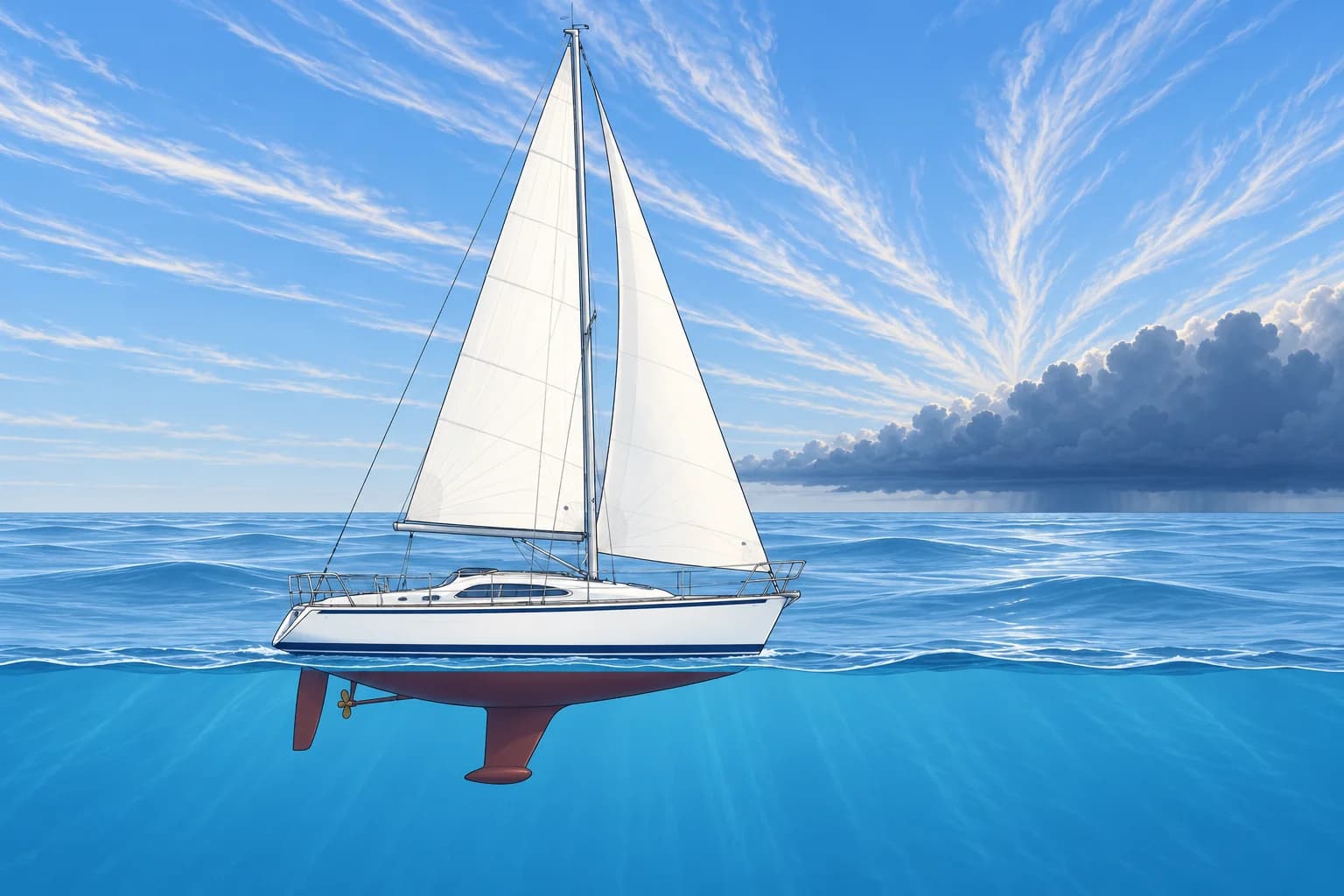
Swell is waves that have left the wind that made them. A new long swell from an unusual direction can warn of a distant cyclone before its winds arrive. Check the advisory. See Onboard forecasting for swell timing.
The barometer
Tropical pressure normally follows a regular twice-daily wave of up to about 3 hPa. Loss of that rhythm is a warning. Reeds gives a traditional warning clue: sea-level pressure about 3 hPa below the local seasonal normal after daily-wave allowance. Pilot charts give normal pressure. Check the advisory and other signs. This does not prove a cyclone or fix its distance or track. An accelerating fall can mean approach, deepening, or both.
Sky and air
Streaks of cirrus, high ice cloud, may fan out from the storm's direction hundreds of miles ahead. Sunsets can be unusually coloured, and visibility unusually clear. Closer in, a dark wall of cloud, the bar, rises on the horizon. Squalls come more often and harder. The centre may still be 100–200 miles away when the bar arrives.
Finding the centre
Buys Ballot's law links wind and pressure. In the northern hemisphere, stand with your back to the true wind: low pressure is on your left. Because the wind spirals inwards, the centre is a little forward of your left beam. Facing the wind, it lies roughly 90°–135° to your right. In the southern hemisphere it is the mirror: back to the wind, the centre is on your right.
Confirm, don't guess
These signs are clues, not a position. Get the latest advisory, plot the centre and compare it with what you observe. If your observations and the forecast disagree, act on the worse of the two and report your weather to the forecasters if you can.
Key figures
- Early warning
- Long swell from an unusual direction can be an early warning.
- Daily pressure wave
- Up to about 3 hPa; its loss is a warning sign
- Pressure warning
- Reeds clue: corrected pressure ~3 hPa below seasonal normal
- The bar
- Dark cloud wall; centre may be 100–200 miles away
- Buys Ballot (north)
- Back to the wind, low on the left
- Buys Ballot (south)
- Back to the wind, low on the right
Remember
- A new long swell from an unusual direction is often the first sign of a distant storm.
- Reeds clue: after sea-level and daily-wave corrections, ~3 hPa below the local seasonal normal warrants suspicion.
- Cirrus, a vivid sky and then the dark bar mark the approach of the storm's cloud shield.
- North: back to the wind, the centre is on your left, slightly forward of the beam. South: on your right.
- Signs are clues: confirm the storm's position with the latest official advisory.
Common mistakes
Wrong: The barometer barely moves in the tropics, so it is no use for storm warning.
Right: Its small, regular daily wave makes any change stand out. Compare with the seasonal normal at the same local time.
Wrong: With your back to the wind, the centre of a northern hemisphere storm is directly behind you.
Right: It is on your left, a little forward of the beam, because the wind spirals in towards the centre.
Wrong: Growing swell proves the storm is heading for you.
Right: Swell shows where waves were made, not where the storm is going. Check its track in the advisory.
Worked case
At 15° N in the Atlantic in late August, the barograph's twice-daily wave has flattened and pressure reads 1009 hPa; the pilot chart gives about 1013 hPa as normal. A long swell is arriving from the east-south-east and cirrus is spreading from the same side. The true wind is north-east. What do you conclude and do?
Show the answer
The pressure and cloud signs justify suspecting a cyclone. Facing the north-east true wind, the northern rule suggests its centre between south-east and south. Swell can indicate an earlier storm position, so the clues do not fix the centre. Get the latest NHC advisory, compare it with your observations and act on the worse case.
Practice question
Which observation is often the earliest sign of a distant tropical cyclone?
- A sudden drop in the sea temperature
- A long swell from an unusual direction
- A sudden thunderstorm right overhead
- A steady increase in the local wind
Show the answer
Answer: B. A new long swell from an unusual direction can be an early warning. It points roughly towards where the waves were generated, not the storm's future track. Check the advisory.
4 · Semicircles
Dangerous and navigable semicircles in both hemispheres
One side of a storm is worse than the other. Learn which side, why, and how wind shifts and pressure trends help you check your position.
Two halves of the storm
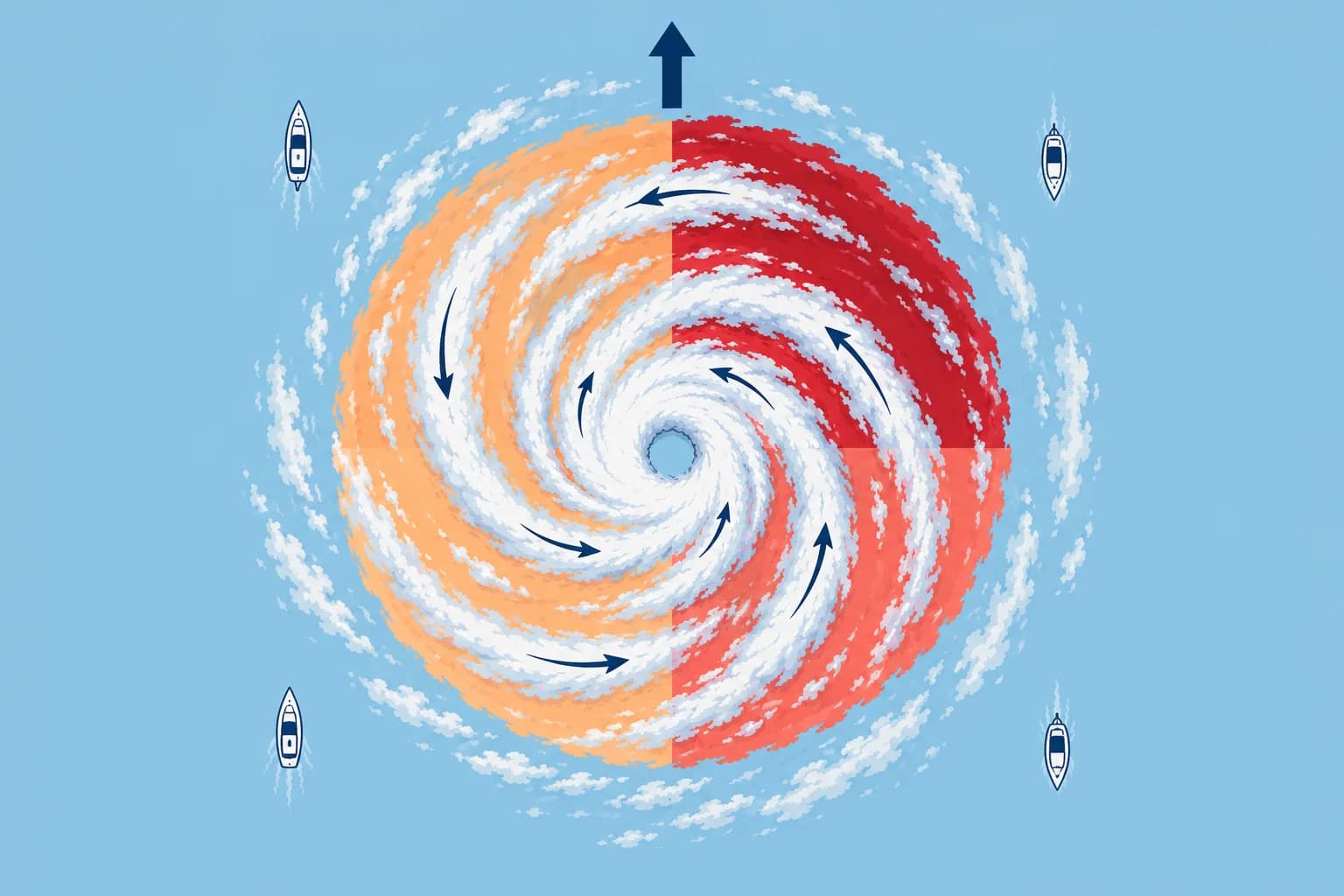
Divide the storm by its track, the line along which the centre moves, and face the way it is going. In the northern hemisphere the dangerous semicircle is on the right and the navigable semicircle on the left. In the southern hemisphere it is the other way round: dangerous on the left, navigable on the right. Navigable means less bad, not safe: hurricane-force winds can blow there too.
Why one side is worse
On the dangerous side the storm's forward speed adds to its rotating wind; on the navigable side it subtracts. Seas are higher on the dangerous side too, because waves travel with the storm and keep growing. The front quadrant of the dangerous side is the worst place of all: its wind pushes a vessel towards the storm's future track.
Reading the wind shift
Use true wind, calculated by removing your boat's motion from apparent wind. For a nearly stationary observer, a steadily moving storm normally gives these shifts: in the north, veering (clockwise) suggests the dangerous semicircle; backing (anticlockwise) suggests the navigable one. In the south, the reverse applies. Your movement through the wind field, or a changing storm, can upset this pattern. Confirm your position from the advisory.
Ahead or behind
For a steadily moving storm of roughly steady strength, with little movement of your own, falling pressure usually suggests you are ahead of the centre; rising pressure suggests it has passed. Steady wind with falling pressure suggests the track ahead; steady wind with rising pressure suggests the track behind. Confirm your position from the advisory.
Key figures
- North, dangerous semicircle
- Right of track; veering true wind suggests this side
- North, navigable semicircle
- Left of track; backing true wind suggests this side
- South, dangerous semicircle
- Left of track; backing true wind suggests this side
- South, navigable semicircle
- Right of track; veering true wind suggests this side
- Steady wind, falling barometer
- Usually suggests the track ahead; confirm with advisory
- Steady wind, rising barometer
- Usually suggests the track behind; confirm with advisory
Remember
- Face the way the storm moves: north, the dangerous side is on the right; south, on the left.
- For a steady storm and little boat movement: veering suggests dangerous in the north; backing does in the south.
- Pressure trends suggest ahead or behind; confirm with the advisory.
- Forward motion strengthens winds on the dangerous side and weakens them on the navigable side.
- Use true wind; boat movement through the wind field and storm changes can upset these clues.
Common mistakes
Wrong: The navigable semicircle is safe to sail in.
Right: It is only less dangerous. Winds there can still reach hurricane force; keep clear of it too.
Wrong: A veering wind always means the dangerous semicircle.
Right: For a steady storm and nearly stationary observer, veering suggests dangerous in the north, navigable in the south. Confirm with the advisory.
Wrong: You can judge the shift from the apparent wind while sailing fast.
Right: Your motion changes apparent wind. Use true wind, but remember that moving through the wind field also changes what you observe. Check the advisory.
Worked case
Near Mauritius in February, a cyclone is approaching. While nearly stationary, you observe the true wind backing from south-east through east to north-east over four hours, with pressure falling. What do these clues suggest? Confirm against the advisory.
Show the answer
South-east through east to north-east is an anticlockwise shift: the wind is backing. For a steadily moving storm of roughly steady strength, these clues suggest the dangerous front quadrant in the southern hemisphere. They do not prove your position: a changing storm can upset the pattern. Confirm your position against the advisory.
Practice question
In the northern hemisphere, which side of a tropical cyclone is the dangerous semicircle?
- The left side, facing the way the storm moves
- The side nearer to the closest coastline
- The right side, facing the way it moves
- The rear half, behind the moving centre
Show the answer
Answer: C. North of the equator the dangerous semicircle is to the right of the track; south of it, to the left.
5 · Avoiding action
Avoiding action near a tropical cyclone
If you are caught near a storm, find your quadrant, then put the wind where it carries you away from the centre: in both hemispheres.

Planning comes first
In seasonal basins, sail outside the main season and keep clear of forecast storms. At 6 knots a yacht covers 144 miles a day; at 15 knots a storm covers 360. The actions below, from NHC and Bowditch, are last resorts. The angles select an initial course. While storm direction and speed stay steady, hold that compass course as the wind shifts, as sailing conditions and sea room permit. Monitor and reassess; do not rely on outrunning a cyclone.
Northern hemisphere
Confirm your quadrant by advisory; trends are clues. Dangerous semicircle, ahead (wind veering, pressure falling): put the wind about 45° on the starboard bow and make the best speed you can; sail close-hauled (as near the wind as practicable) on starboard tack. Navigable semicircle, ahead (wind backing): put the wind about 135° on the starboard quarter. On the track, ahead (steady wind, pressure falling): put the wind about 160° on the starboard quarter and run into the navigable semicircle.
Southern hemisphere
Mirror the north; confirm your quadrant from the advisory. Dangerous semicircle, ahead (wind backing, pressure falling): wind about 45° on the port bow, best safe speed; a yacht initially close-hauled on port tack. Navigable semicircle, ahead (wind veering): wind about 135° on the port quarter. On the track, ahead (steady wind, pressure falling): wind about 160° on the port quarter, into the navigable semicircle. Behind: keep wind on the starboard side north, port side south; adjust course and speed for the best ride and monitor the track.
If you must heave to
Heave to on the tack that lets the shifting wind draw aft, towards your stern. North: starboard tack in the dangerous semicircle, port tack in the navigable one. South: port tack in the dangerous semicircle, starboard tack in the navigable one. Never run with wind and sea on the quarter in the front of the dangerous semicircle: that carries you towards the centre. Storm tactics has its own unit.
Don't cross the T
Crossing ahead of a storm's track is the classic fatal mistake: a breakage or a loss of speed leaves you in its path. Passing behind it is far safer, even if the route is longer. Re-plot after every new advisory, every six hours.
Key figures
- North, dangerous, ahead
- Wind about 45° on the starboard bow, best speed
- North, navigable or on track ahead
- Wind about 135° (160° on track) on the starboard quarter
- South, dangerous, ahead
- Wind about 45° on the port bow, best speed
- South, navigable or on track ahead
- Wind about 135° (160° on track) on the port quarter
- Heave to (north)
- Starboard tack dangerous; port tack navigable
- Heave to (south)
- Port tack dangerous; starboard tack navigable
When a storm threatens
- Get the latest advisory; plot the centre, track and 34-knot radii. — Your position relative to the storm decides everything that follows.
- Start logging true wind and pressure now; keep recording while you act. Do not delay avoiding action. — Trends help check your plotted position; they take time to establish.
- Use the advisory to establish your quadrant; cross-check with observed trends. — The northern and southern rules are mirror images; mixing them is fatal.
- Choose the indicated initial course and make best safe speed. While storm direction and speed stay steady, hold that course as the wind shifts, as sailing conditions and sea room permit. — The wind angle selects the course; keep monitoring the track and reassess when storm motion or sailing conditions change.
- Never cross ahead of the track; pass behind if you must cross. — Damage or lost speed ahead of the storm leaves you in its path.
- Re-plot with every new advisory and adjust early. — Tracks change; a small early change beats a large late one.
Remember
- North, dangerous semicircle: wind on the starboard bow. South, dangerous semicircle: wind on the port bow.
- Navigable semicircle or on the track ahead: run with the wind on the starboard (north) or port (south) quarter.
- Heave to on the tack that lets the shifting wind draw aft, towards your stern.
- Never cross ahead of a storm's track; pass behind it.
- These are last resorts: in seasonal basins, plan outside the main season and keep clear of forecast storms.
Common mistakes
Wrong: In any hemisphere, put the wind on the starboard bow in the dangerous semicircle.
Right: Starboard bow is the northern hemisphere rule. In the southern hemisphere it is the port bow.
Wrong: Run before the wind to escape fastest, wherever you are in the storm.
Right: In the front of the dangerous semicircle, running carries you towards the centre. Keep the wind on the bow there.
Wrong: Cross quickly ahead of the storm to reach the other side.
Right: Don't cross the T. A breakage or loss of speed would leave you in its path; pass behind it.
Worked case
In the North Atlantic, the latest advisory places you ahead and to the right of a north-west-moving hurricane. The true wind is veering and pressure is falling. Your 12 m sloop can sail close-hauled in the present 30 knots. What do you do?
Show the answer
You are ahead of the centre in the dangerous semicircle. Start with wind about 45° on the starboard bow, close-hauled on starboard tack, at best safe speed. While storm direction and speed stay steady, hold the selected compass course as the wind shifts, as sailing conditions and sea room permit. Do not run off. Re-plot each advisory; if you must heave to, use starboard tack.
Practice question
Northern hemisphere, dangerous semicircle, ahead of the centre. Where should you initially put the wind?
- About 135° on the starboard quarter
- About 45° on the starboard bow
- About 45° on the port bow
- Right astern, running at full speed
Show the answer
Answer: B. Use about 45° on the starboard bow to select your initial course. While storm direction and speed stay steady, hold that course as the wind shifts, as sailing conditions and sea room permit. Monitor and reassess.
6 · NHC, JTWC, 34 kt
Storm warnings: NHC and JTWC products and the 34-knot rule
Official advisories give the storm's position, track, wind radii and uncertainty. Use them to keep your boat out of the area of possible 34-knot winds.
Forecast centres
The World Meteorological Organization (WMO) coordinates warnings through Regional Specialized Meteorological Centres (RSMCs) and Tropical Cyclone Warning Centres (TCWCs). RSMCs include Miami, Honolulu, Tokyo, New Delhi, La Réunion and Nadi. The US National Hurricane Center (NHC) now handles Atlantic, eastern-Pacific and central-Pacific tropical products. Central Pacific Hurricane Center (CPHC) headers remain in 2026. The US Joint Typhoon Warning Center (JTWC) adds western Pacific and Indian Ocean guidance. NHC and JTWC use 1-minute mean winds; most other centres use 10-minute means, generally giving lower values.
The forecast advisory
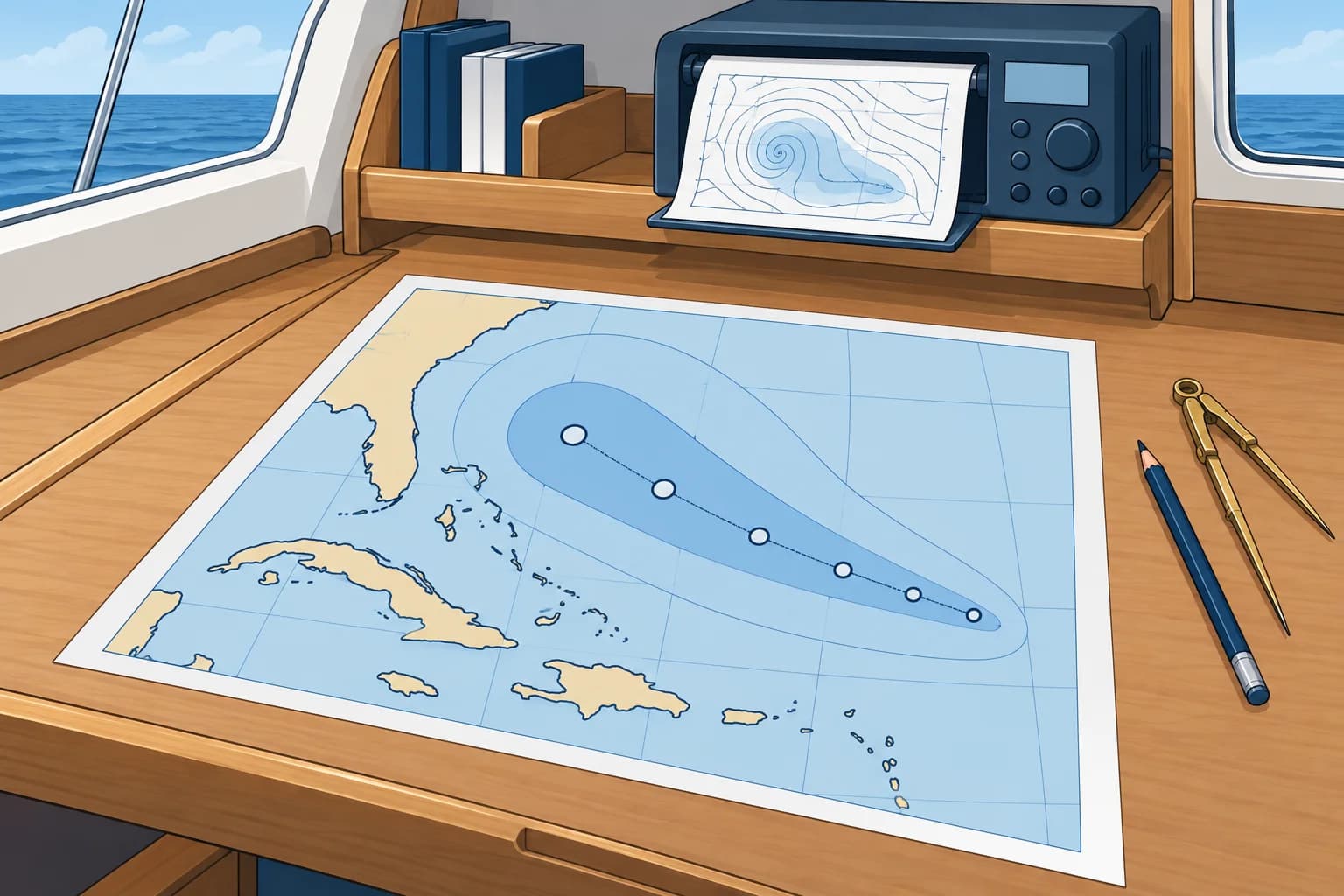
NHC's Tropical Cyclone Forecast/Advisory (TCM) is the key text for mariners, in knots, nautical miles and UTC. It comes every 6 hours, at 0300, 0900, 1500 and 2100 UTC. It gives position, movement, peak wind and the wind radii: the greatest distance of 34-, 50- and 64-knot winds in each quadrant (NE, SE, SW, NW). Since 2025 it also gives the current maximum extent of 4-metre seas by quadrant.
Radii and the cone
34- and 50-knot radii are forecast to 5 days and 64-knot radii to 3 days. Each is the farthest extent in that quadrant. The operational cone shows only where the centre may go: in 2026 its Atlantic circles are 39 miles at 24 hours, 62 at 48 and 95 at 72. These circles contain two-thirds of historical centre-position errors at each forecast lead time.
From 1-2-3 to the 34-knot rule
The old mariner's 1-2-3 rule added 100, 200 and 300 miles to the 34-knot radius at 24, 48 and 72 hours, and avoided the lot. It assumed errors of about 100 miles a day. Errors are now far smaller, so NHC no longer endorses it. Today's 34-knot rule: stay out of the area where 34-knot winds are possible. US Navy ship routers avoid a chance of over 5 %.
The danger graphic
NHC publishes the Tropical Cyclone Danger Graphic. It shows where tropical-storm-force winds are possible (at least 5 %) or likely (at least 50 %) over 72 hours. It is updated four times a day. JTWC's warning graphic shows a similar danger area. Do not rely on outrunning a cyclone. For a yacht, use lower wind and sea limits when needed; being outside this area does not guarantee suitable conditions.
Worked closest approach
Your time-matched plot puts the centre 120 nautical miles (nm) east and 240 nm north of your boat at 24 hours, then 120 nm west and 240 nm north at 48 hours. Assuming straight, steady relative motion, closest point of approach (CPA) is halfway between: 36 hours, 240 nm. With a forecast 34-knot radius of 180 nm in your quadrant then, nominal clearance is 60 nm. That is not a safety margin: check wind probabilities and allow generously for uncertainty.
Key figures
- TCM issue times
- 0300, 0900, 1500, 2100 UTC (every 6 hours)
- Wind radii
- 34/50 kn to 5 days; 64 kn to 3 days (since 2025)
- 2026 Atlantic operational cone circles
- 39 / 62 / 95 nm at 24 / 48 / 72 h (two-thirds of errors)
- Old 1-2-3 rule
- 34-kn radius + 100 / 200 / 300 nm at 24 / 48 / 72 h
- 34-knot rule
- Avoid where 34-kn winds are possible (US Navy: over 5 %)
- Danger Graphic
- 34-kn winds possible (5 %) and likely (50 %), 72 h, 4 times a day
Remember
- Use the forecast advisory (TCM) for position, track and wind radii; it is in knots, miles and UTC.
- A wind radius is the farthest extent of that wind in one quadrant.
- The cone describes centre-position uncertainty, not wind extent or a safe boundary.
- The 1-2-3 rule is outdated; today avoid the area where 34-knot winds are possible.
- JTWC uses 1-minute winds; most RSMCs use 10-minute means, generally giving lower values. Intensity estimates also differ.
Common mistakes
Wrong: Outside the cone you are safe from the storm.
Right: The cone shows only centre-position uncertainty. Gales extend far beyond it, and its circles are not maximum error limits.
Wrong: The 34-knot radius means there are 34-knot winds everywhere within that distance.
Right: It is the farthest extent in that quadrant. Winds are not uniform, and other quadrants can be much smaller.
Wrong: JTWC and RSMC Tokyo disagree on the wind, so one of them is wrong.
Right: JTWC uses 1-minute means and Tokyo 10-minute means. Longer averages generally give lower values; independent intensity estimates can also differ.
Worked case
The 72-hour forecast for a hurricane gives a largest 34-knot radius of 200 miles. A crew member applies the 1-2-3 rule and wants to stay 500 miles from the forecast centre, which would cost two days. You have the latest Danger Graphic. What do you explain?
Show the answer
The old rule gives 200 + 300 = 500 nautical miles, based on an assumed 300-mile error at 72 hours. The 95-mile cone circle is not a maximum error. Use the Danger Graphic or 34-knot wind probabilities to see where tropical-storm-force winds are possible. Keep outside that area with a generous margin for a slow boat. Recheck with every update.
Practice question
What does the 34-knot wind radius in the NE quadrant of an advisory give?
- The average wind speed in that quadrant
- Farthest extent of 34-knot winds there
- The distance the storm will move in a day
- The radius of the eye within that quadrant
Show the answer
Answer: B. Each radius is the greatest distance from the centre at which that wind speed occurs in the quadrant.