
Navigation · Level R5 · 5 parts · about 14 min
Great-circle sailing: distance, initial course and vertex
5 short parts: Why great circles · Distance, course · Vertex, waypoints · Composite · Gnomonic charts. Each part explains the idea, then gives the points to remember, the common mistakes, a worked case and a practice question; the Academy unit adds all 27 check questions.
1 · Why great circles
Great circles and rhumb lines
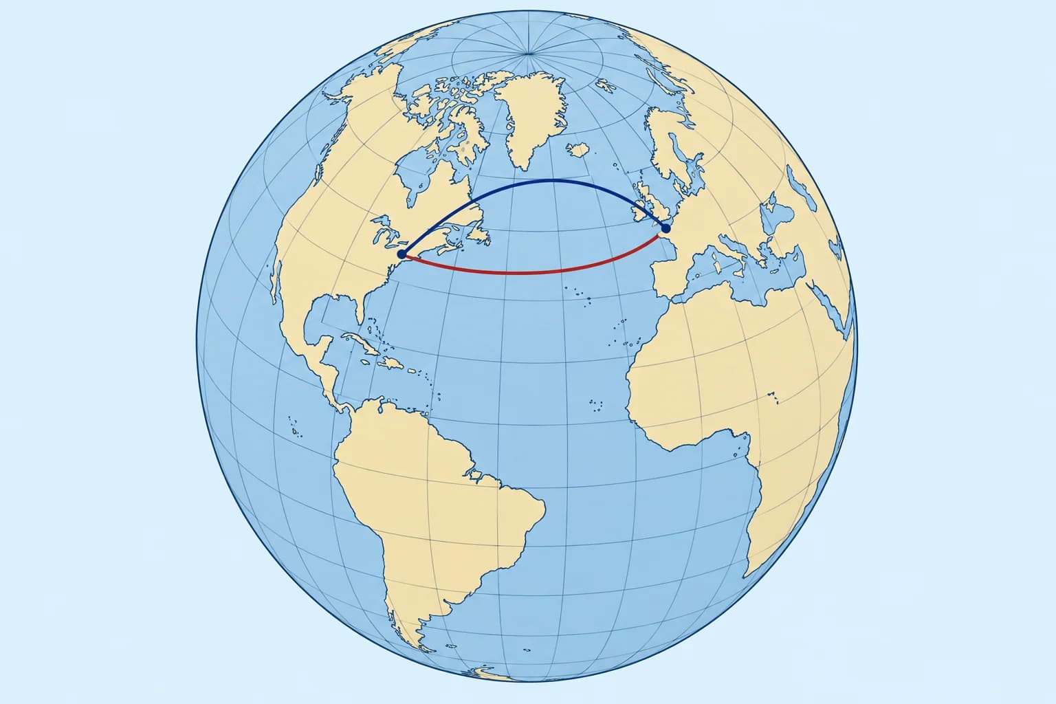
A great circle gives the shortest route on a sphere. Its course changes except along a meridian or the equator. Savings grow with latitude and east–west span.
Great circle
A great circle is any circle on the Earth whose centre is the Earth's centre: the equator, every meridian, and countless slanting ones. The shorter arc of the great circle through two points is the shortest route between them on a sphere. Sailing along it is great-circle sailing.
Rhumb line
A rhumb line crosses every meridian at the same angle, so you steer one true course. On a Mercator chart it is a straight line (Navigation: rhumb-line sailing). Except along a meridian or the equator, it is longer than the great circle.
Changing course
Except along meridians or the equator, a great circle’s true course changes. A northern-hemisphere arc bends poleward compared with the rhumb line. On Mercator it looks curved. In practice you split it into rhumb-line legs between waypoints and alter course at each.
When it pays
The saving grows with latitude and with the east–west span. From Newport, Rhode Island to Falmouth, England, the great circle is 2,730 M and the rhumb line 2,815 M: 85 M shorter. From Las Palmas to Saint Lucia, nearer the equator, it saves only about 10 M. M means nautical miles.
Wind first
For a sailing yacht, wind, current and weather usually decide the route; the great circle is the baseline you compare against. Motor vessels and ships gain most from following it (Navigation: ocean passage planning).
Key figures
- Great circle
- Circle centred on the Earth's centre; shortest route on a sphere
- Rhumb line
- Constant true course; straight on a Mercator chart
- Same route when
- Along a meridian or the equator
- Newport → Falmouth
- Great circle 2,730 M, rhumb line 2,815 M: saves 85 M
- Las Palmas → Saint Lucia
- Saves only about 10 M (low latitude)
Remember
- The great circle is shortest on a sphere; its course changes except along a meridian or the equator.
- The rhumb line keeps one course; it is straight on a Mercator chart and usually longer.
- Savings grow with latitude and east–west span; they are small near the equator.
- Sail a great circle as a series of rhumb-line legs between waypoints.
Common mistakes
Wrong: The straight line on a Mercator chart is the shortest route.
Right: Usually the shortest route curves poleward. Along a meridian or the equator, the straight rhumb line is also the great circle.
Wrong: A great circle always saves hundreds of miles on an ocean crossing.
Right: Near the equator the saving is small: about 10 M from Las Palmas to Saint Lucia.
Wrong: On a great circle you steer the initial course all the way.
Right: Except along a meridian or the equator, the course changes. Steer rhumb-line legs and alter course at each waypoint.
Worked case
A motor-yacht skipper plans Newport, Rhode Island to Falmouth by drawing a straight line on a Mercator ocean chart and steering 079°T throughout. What do you point out?
Show the answer
That straight line is the rhumb line, about 2,815 M. The great circle is about 2,730 M, some 85 M shorter, starting near 055°T and bending north of the rhumb line. For a motor yacht, fuel and time favour it, ice and weather permitting. Plan it as rhumb-line legs between waypoints along the great circle.
Practice question
Which route is the shortest between two points on a sphere?
- The direct rhumb line
- The great-circle arc
- The parallel of latitude
- The Mercator straight line
Show the answer
Answer: B. The shorter arc of the great circle through two points is the shortest route on a sphere.
2 · Distance, course
Worked: distance and initial course, Las Palmas to Saint Lucia
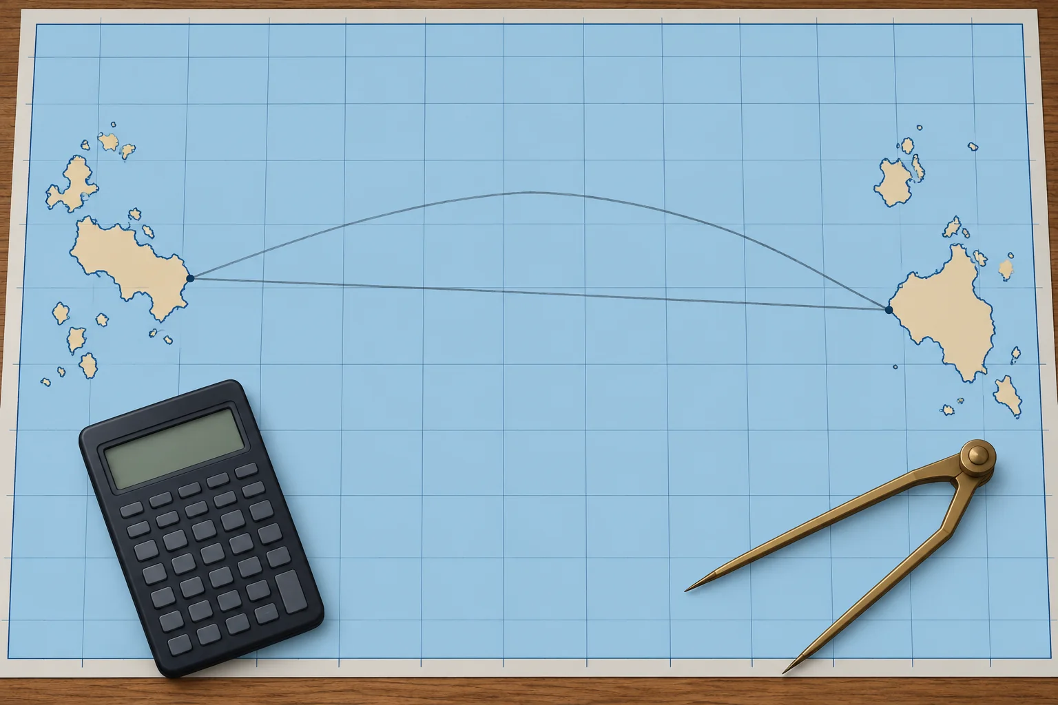
The spherical cosine formula gives the great-circle distance; a second formula gives the initial course. Work through an Atlantic crossing.
Distance
cos d = sin L1 × sin L2 + cos L1 × cos L2 × cos d.long. L1 is the departure latitude, L2 the destination's; give south latitudes a minus sign. d.long is the difference of longitude, never more than 180°. Turn d from degrees into minutes: each minute is a nautical mile, on a sphere.
Initial course
cos C = (sin L2 − sin L1 × cos d) ÷ (cos L1 × sin d). C runs from 0° to 180°, measured from north. Name it towards your destination: heading east, the course is C; heading west, it is 360° − C.
Worked: the data
From off Las Palmas, 28°07.6′N 015°25.4′W, to Rodney Bay, Saint Lucia, 14°05.0′N 060°58.0′W. d.long = 45°32.6′ W.
Worked: distance
sin 28°07.6′ × sin 14°05.0′ = 0.1147. cos 28°07.6′ × cos 14°05.0′ × cos 45°32.6′ = 0.5991. Sum 0.7138, so d = 44.455° = 2,667.3 M.
Worked: course
The cosine formula gives C = 98.7°. You are heading west, so the initial course is 360° − 98.7° = 261.3°T. By the time you arrive, the course has turned to 244.0°T.
Against the rhumb line
Mercator sailing gives the rhumb line as about 252°T for 2,677.1 M. The great circle saves only about 10 M, 0.4 %. On the WGS84 ellipsoid, the shortest distance is 2,671.7 M: spherical formulas are good to a few miles here.
Key figures
- Distance
- cos d = sin L1 sin L2 + cos L1 cos L2 cos d.long
- Initial course
- cos C = (sin L2 − sin L1 cos d) ÷ (cos L1 sin d)
- Worked distance
- Las Palmas → Rodney Bay: 2,667.3 M
- Worked courses
- Initial 261.3°T; final 244.0°T
- Rhumb line
- About 252°T, 2,677.1 M: great circle saves about 10 M
- Ellipsoid check
- WGS84 shortest distance 2,671.7 M
Great-circle distance and initial course
- Write both positions; find d.long and name it E or W. — d.long must be the short way round, not more than 180°.
- cos d = sin L1 sin L2 + cos L1 cos L2 cos d.long; S latitudes negative. — The spherical cosine formula solves the triangle with the pole.
- Multiply d in degrees by 60 to get nautical miles. — On a sphere, one minute of arc is one nautical mile.
- cos C = (sin L2 − sin L1 cos d) ÷ (cos L1 sin d). — This gives the initial course angle from north, 0°–180°.
- Name it: east-going C; west-going 360° − C. — The formula does not show which side of north you turn.
- Compare with the rhumb line and check on a chart. — A gross error shows at once; the saving decides if it is worth it.
Remember
- cos d = sin L1 sin L2 + cos L1 cos L2 cos d.long; south latitudes negative.
- d in degrees × 60 = distance in nautical miles, on a sphere.
- Initial course from the cosine formula; name it 360° − C when heading west.
- Worked: 2,667.3 M, initial 261.3°T, final 244.0°T; rhumb 2,677.1 M.
Common mistakes
Wrong: Use departure (miles) instead of d.long in the cosine formula.
Right: The formula needs d.long in degrees and minutes of arc, the angle at the pole.
Wrong: Take C = 98.7° as the course to steer.
Right: C is measured from north towards either side. Heading west, the course is 360° − 98.7° = 261.3°T.
Wrong: Give a south latitude a plus sign like a north one.
Right: Use a minus sign for south latitude, or the distance and course will be wrong for any route crossing the equator.
Worked case
A crew member works Las Palmas to Rodney Bay and gets 2,667 M and an initial course of 098.7°T. The distance looks right. Is the plan sound?
Show the answer
The distance is right, but the course points east of south-east, away from the Caribbean. The formula's C = 98.7° is measured from north; heading west, the course is 360° − 98.7° = 261.3°T. A quick look at the chart catches this: Saint Lucia lies to the west-south-west.
Practice question
What is d.long from 015°25.4′W to 060°58.0′W?
- 76°23.4′ W
- 45°32.6′ W
- 45°32.6′ E
- 44°27.3′ W
Show the answer
Answer: B. Both are west: 60°58.0′ − 15°25.4′ = 45°32.6′, westward.
3 · Vertex, waypoints
The vertex and waypoints along the track
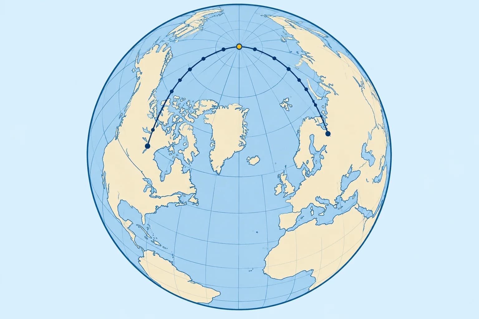
A vertex marks a great circle’s poleward extreme. It may lie outside your sailed arc. Use it to calculate waypoint latitudes.
The vertex
On a non-meridional great circle other than the equator, a vertex is a point of greatest north or south latitude, where the track is due east or west. The two vertices are opposite. A vertex may lie outside your sailed arc. Only a vertex on that arc gives its greatest poleward latitude; otherwise use the endpoints. Meridional great circles pass through the poles, where true course is undefined.
Finding it
Use the vertex in your departure hemisphere. With initial angle C (0°–180°) measured from north, cos Lv = cos L1 × sin C gives its latitude magnitude. sin d.long v = |cos C| ÷ sin Lv gives a separation of 0°–90°. The vertex is ahead when you head poleward, behind when you head equatorward. North: C < 90° is poleward. South: C > 90° is poleward. At C = 90° you are at the vertex. Use a negative Lv for a southern vertex in the waypoint formula.
Worked: the vertex
Las Palmas to Rodney Bay: using the unrounded initial angle, Lv = 29°19.8′N. d.long = 17°56′. From this northern start, C is over 90°, so the northern vertex lies 17°56′ east of Las Palmas, at 002°31′E, behind the start. All the way to Saint Lucia, the latitude falls.
Waypoints
Measure longitude from the vertex: tan L = tan Lv × cos (d.long from the vertex). For this Atlantic crossing: 030°W, 25°21.1′N; 045°W, 20°46.8′N; 060°W, 14°32.2′N. Choose waypoints every 5° or 10° of longitude, and steer the rhumb line between each pair.
Course along the track
sin (course angle) = cos Lv ÷ cos L; choose the quadrant from the track direction. On this westbound, equatorward northern track, true course is 180° + arcsin(cos Lv ÷ cos L): 261.3°T at departure, 254.7°T at 030°W, 248.8°T at 045°W and 244.0°T on arrival. These are tangent courses: the direction at each point on the great circle. Calculate the rhumb-line course separately for each waypoint leg.
Key figures
- Vertex latitude
- cos Lv = cos L1 × sin C
- D.long to vertex
- sin d.long v = cos C ÷ sin Lv (magnitudes)
- Waypoint latitude
- tan L = tan Lv × cos (d.long from vertex)
- Worked vertex
- 29°19.8′N at 002°31′E, behind Las Palmas
- Worked waypoints
- 30°W 25°21.1′N; 45°W 20°46.8′N; 60°W 14°32.2′N
- Worked courses
- 261.3° start, 254.7° at 30°W, 248.8° at 45°W, 244.0° end
Remember
- Except on meridians or the equator, a vertex is a poleward extreme where the track is due east or west.
- cos Lv = cos L1 × sin C; it may lie between your points or outside them.
- Waypoints: tan L = tan Lv × cos (d.long from the vertex).
- Steer rhumb lines between waypoints every 5° or 10° of longitude.
Common mistakes
Wrong: The vertex always lies somewhere between the two ports.
Right: It can lie outside them. From Las Palmas, the vertex is behind the start, at 002°31′E.
Wrong: Measure d.long for the waypoint formula from the departure point.
Right: The formula tan L = tan Lv × cos (d.long) uses d.long measured from the vertex.
Worked case
A crew member says the Las Palmas to Rodney Bay great circle “goes up to 29°N in mid-ocean”. Is that right?
Show the answer
No. The vertex, 29°19.8′N, lies at 002°31′E, behind Las Palmas. The part you sail is entirely on the descending side: the latitude falls from 28°08′N to 14°05′N, passing 25°21′N at 030°W and 20°47′N at 045°W. The great circle runs north of the rhumb line, by up to about 1°48′ of latitude near 038°W, but never above your start latitude.
Practice question
On a non-meridional great circle other than the equator, what is a vertex?
- A point of greatest north or south latitude
- A point halfway along the planned passage
- A point where the track crosses the equator
- A point where the track crosses a rhumb line
Show the answer
Answer: A. A vertex is a point of greatest north or south latitude on this great circle. The track there is due east or west.
4 · Composite
The composite great circle: a limiting latitude
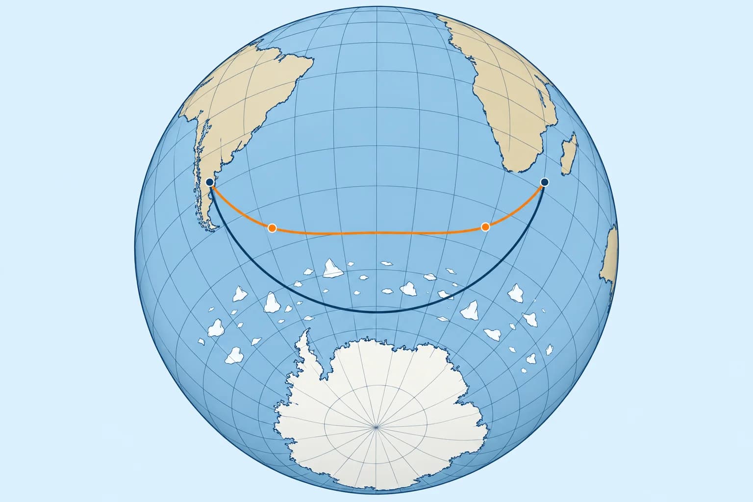
When the great circle goes too far towards the pole, set a limiting latitude. Sail a great circle to it, along it, and a great circle away from it.
Why
A great circle in high latitudes may run into ice, icebergs or the worst gales. Then you choose a limiting latitude, a parallel you will not cross. The composite great circle is the shortest route that respects it: a great circle from the start with its vertex on the limit, along the limit, and a great circle from the limit to the destination.
The formulas
Let L be the port latitude and Llim the limiting latitude. For each great-circle leg, cos Δλ = tan L ÷ tan Llim and cos d = sin L ÷ sin Llim. Here Δλ is longitude difference to the vertex and d is angular distance. Use degree mode; d × 60 gives nautical miles. For the parallel leg, longitude difference in degrees × 60 × cos Llim gives nautical miles.
Worked: the problem
From south of Cape Agulhas, 35°00′S 020°00′E, to south-east Tasmania, 43°40′S 146°50′E. The great circle is 5,259.7 M, but its vertex is at 61°40′S, deep in iceberg waters. You set a limit of 47°S.
Worked: the answer
Leg 1: d.long 49°14′, 2,300.8 M, to 47°S at 069°14′E. Along 47°S to 119°43′E: 50°29′ × 60 × cos 47° = 2,065.8 M. Leg 2: d.long 27°07′, 1,155.0 M. Total 5,521.6 M: 262 M more than the great circle, 374 M less than the rhumb line.
Choosing the limit
The limit comes from ice charts and ice limits for the season, the weather, the boat and crew, and any race rules (Meteorology: global winds and sea ice). Check the latest ice information before departure and during the passage.
Key figures
- Composite
- Great circle to the limit, along it, great circle from it
- Leg to limit
- cos Δλ = tan L ÷ tan Llim; cos d = sin L ÷ sin Llim; d° × 60 = M
- Parallel leg
- 60 × d.long (degrees) × cos Llim = nautical miles
- Worked limit
- Agulhas → Tasmania, limit 47°S; great-circle vertex 61°40′S
- Worked distances
- 2,300.8 + 2,065.8 + 1,155.0 = 5,521.6 M
- Comparison
- Great circle 5,259.7 M; composite 5,521.6 M; rhumb 5,895.9 M
Remember
- A limiting latitude caps poleward travel; choose it using current ice and weather information.
- The composite route: great circle to the limit, along it, great circle away.
- Each great-circle leg has its vertex on the limit: cos d.long = tan L ÷ tan Llim.
- Worked: 5,521.6 M against 5,259.7 M direct and 5,895.9 M by rhumb line.
Common mistakes
Wrong: Sail the great circle and simply turn back north when you reach the limit.
Right: That is longer. The composite route meets the limit along great circles whose vertices lie on it.
Wrong: Measure the parallel leg as d.long in minutes.
Right: Along a parallel, distance = d.long in degrees × 60 × cos Llim: here (50 + 29/60) × 60 × cos 47° ≈ 2,066 M.
Worked case
Cape Agulhas to Tasmania. The great circle reaches 61°40′S. A crew member suggests the rhumb line instead, to stay north. With a limit of 47°S, what do you recommend and why?
Show the answer
The composite great circle. It keeps you north of 47°S, as the rhumb line does, but saves about 374 M: 5,521.6 M against 5,895.9 M. It costs 262 M over the direct great circle, which is the cost of respecting the chosen latitude limit. Confirm the limit against the latest ice information.
Practice question
Why would you sail a composite great circle?
- To shorten the direct great circle
- To respect a chosen latitude limit
- To steer one constant course throughout
- To keep close to the equator and its winds
Show the answer
Answer: B. A composite route respects a chosen poleward limit at some extra distance. Choose and review the limit using current ice and weather information.
5 · Gnomonic charts
Gnomonic charts and great circles in practice
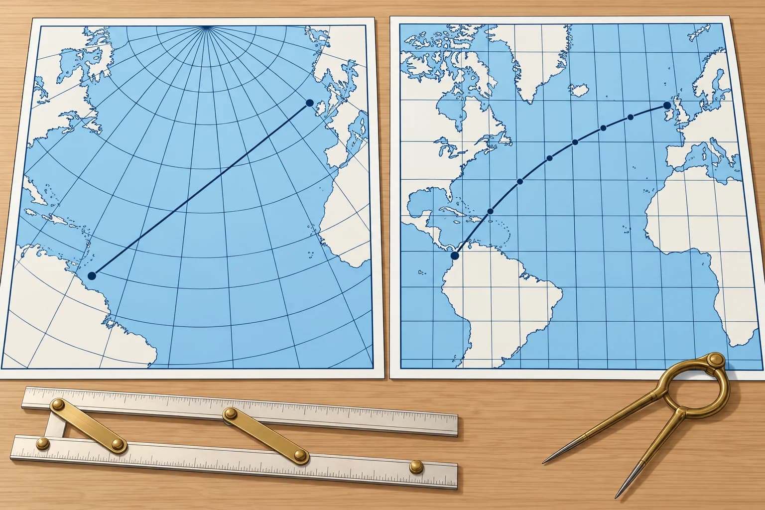
On a gnomonic chart every great circle is a straight line. Draw the route there, read off waypoints, and plot them on the Mercator chart.
The projection
A gnomonic chart projects the Earth from its centre onto a flat plane touching it at one point. Every great circle becomes a straight line. Distances and angles are distorted, more so away from the centre, so you do not measure courses or distances on it.
Using it
Draw a straight line between departure and destination: that is the great circle. Check that it clears land, ice and dangers. Read the latitude where it crosses every 5° or 10° meridian. Plot and join those waypoints on Mercator, then check every resulting rhumb-line leg for hazards.
Electronic route
Chart plotters, an Electronic Chart Display and Information System (ECDIS), and routeing software calculate great-circle routes directly and split them into legs. Check that every connecting leg clears land and hazards, that the legs are sensible, and that the route is what you meant. Keep a hand method as a cross-check.
Wind before geometry
Sailing yachts rarely follow the great circle on a trade-wind passage. On the Atlantic rally route, crews usually head south-west first to find the trade winds, then run west. The great circle is the yardstick for distance; the wind and current set the route (Navigation: ocean passage planning).
Spanish exams
The Spanish Capitán de Yate syllabus includes great-circle sailing (navegación ortodrómica) among its navigation calculations. Practise distance, initial course, vertex and waypoints by hand, checking every sign and quadrant.
Key figures
- Gnomonic chart
- Projected from the Earth's centre; great circles are straight
- Do not measure
- Courses or distances on a gnomonic chart
- Transfer
- Read waypoints every 5° or 10° of longitude onto Mercator
- Electronic
- Plotters and ECDIS compute great-circle legs; check them
- Sailing practice
- Wind and current decide; the great circle is the yardstick
Remember
- On a gnomonic chart every great circle is a straight line.
- Draw the route there, read waypoints, transfer them to the Mercator chart.
- Never measure courses or distances on a gnomonic chart.
- Electronic great-circle routes still need checking against land, ice and hazards.
Common mistakes
Wrong: Measure the course to steer with a protractor on the gnomonic chart.
Right: Angles are distorted on a gnomonic chart. Use it for the track, then work courses on the Mercator chart or by calculation.
Wrong: A plotter's great-circle route is safe because the computer drew it.
Right: The plotter calculates geometry, not seamanship. Check every leg against land, ice and other hazards.
Worked case
Your gnomonic great circle clears a danger, but one straight Mercator leg between transferred waypoints crosses it. Can you use that route?
Show the answer
No. You will sail the connecting legs. Add or move waypoints to clear the danger, then recheck every leg on Mercator. A clear great-circle curve does not guarantee clear legs.
Practice question
What does a straight line on a gnomonic chart represent?
- A rhumb-line track
- A latitude parallel
- A great-circle track
- A magnetic variation line
Show the answer
Answer: C. The gnomonic projection, from the Earth's centre, makes every great circle a straight line.